
Topografische Karte Black Canyon
Interaktive Karte
Klicken Sie auf die Karte, um die Höhe anzuzeigen.
Über diese Karte
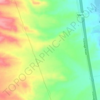
Name: Topografische Karte Black Canyon, Höhe, Relief.
Durchschnittliche Höhe: 1.453 m
Minimale Höhe: 1.398 m
Maximale Höhe: 1.522 m
Andere topografische Karten
Klicken Sie auf eine Karte, um ihre Topografie, ihre Höhe und ihr Relief anzuzeigen.
Alamogordo
United States of America > New Mexico > Alamogordo
Alamogordo, Otero County, New Mexico, United States of America
Durchschnittliche Höhe: 1.515 m
Glorieta
United States of America > New Mexico > Glorieta
Glorieta, Santa Fe County, New Mexico, 87535, United States of America
Durchschnittliche Höhe: 2.313 m
Gallup
United States of America > New Mexico > Gallup
Gallup, McKinley County, New Mexico, United States of America
Durchschnittliche Höhe: 2.067 m
Seton Village
United States of America > New Mexico > Seton Village
Seton Village, Santa Fe County, New Mexico, United States of America
Durchschnittliche Höhe: 2.140 m