
Topografische Karte San Rafael
Interaktive Karte
Klicken Sie auf die Karte, um die Höhe anzuzeigen.
Über diese Karte
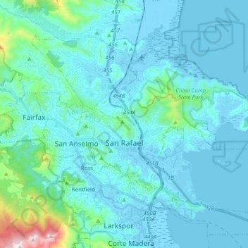
Name: Topografische Karte San Rafael, Höhe, Relief.
Durchschnittliche Höhe: 78 m
Minimale Höhe: -6 m
Maximale Höhe: 778 m
San Rafael has a wide diversity of natural habitats from forests at the higher elevations to marshland and estuarine settings. Its marshes are home to the endangered species Salt Marsh Harvest Mouse. There are also riparian areas including the San Rafael Creek and Miller Creek corridors.