
Topografische Karte Gavdos
Interaktive Karte
Klicken Sie auf die Karte, um die Höhe anzuzeigen.
Über diese Karte
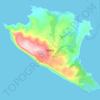
Name: Topografische Karte Gavdos, Höhe, Relief.
Durchschnittliche Höhe: 56 m
Minimale Höhe: -2 m
Maximale Höhe: 368 m
Andere topografische Karten
Klicken Sie auf eine Karte, um ihre Topografie, ihre Höhe und ihr Relief anzuzeigen.
Lefkogia
Greece > Region of Crete > Rethymno Regional Unit
Lefkogia, Municipality of Agios Vasileios, Rethymno Regional Unit, Region of Crete, 740 60, Greece
Durchschnittliche Höhe: 150 m
Traostalos
Greece > Region of Crete > Lasithi Regional Unit > Itanos Municipal Unit
Traostalos, Itanos Municipal Unit, Municipality of Sitia, Lasithi Regional Unit, Region of Crete, Greece
Durchschnittliche Höhe: 272 m
Panormos
Greece > Region of Crete > Panormos
Panormos, District of Milopotamos, Rethymno Regional Unit, Region of Crete, 740 57, Greece
Durchschnittliche Höhe: 32 m
District of Chania
Greece > Region of Crete > District of Chania
District of Chania, Chania Regional Unit, Region of Crete, Greece
Durchschnittliche Höhe: 353 m