
Topografische Karte Melbourne
Klicken Sie auf die Karte, um die Höhe anzuzeigen.
Melbourne
Melbourne is also prone to isolated convective showers forming when a cold pool crosses the state, especially if there is considerable daytime heating. These showers are often heavy and can include hail, squalls, and significant drops in temperature, but they often pass through very quickly with a rapid clearing trend to sunny and relatively calm weather and the temperature rising back to what it was before the shower. This can occur in the space of minutes and can be repeated many times a day, giving Melbourne a reputation for having "four seasons in one day", a phrase that is part of local popular culture. The lowest temperature on record is −2.8 °C (27.0 °F), on 21 July 1869. The highest temperature recorded in Melbourne city was 46.4 °C (115.5 °F), on 7 February 2009. While snow is occasionally seen at higher elevations in the outskirts of the city, it has not been recorded in the Central Business District since 1986.
Über diese Karte
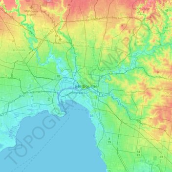
Name: Topografische Karte Melbourne, Höhe, Relief.
Ort: Melbourne, City of Melbourne, Victoria, Australia (-37.97425 144.80317 -37.65425 145.12317)
Durchschnittliche Höhe: 49 m
Minimale Höhe: -5 m
Maximale Höhe: 191 m
Andere topografische Karten
Klicken Sie auf eine Karte, um ihre Topografie, ihre Höhe und ihr Relief anzuzeigen.
City of Melbourne
Melbourne's topography is characterized by a diverse landscape that transitions from flat coastal plains to rolling hills and mountainous regions. The city is situated at the northern end of Port Phillip Bay, where the terrain is predominantly flat, facilitating urban development. As one moves eastward, the…
Durchschnittliche Höhe: 18 m
Melbourne
Melbourne is also prone to isolated convective showers forming when a cold pool crosses the state, especially if there is considerable daytime heating. These showers are often heavy and can include hail, squalls, and significant drops in temperature, but they often pass through very quickly with a rapid…
Durchschnittliche Höhe: 185 m
Trentham
Trentham is a small town in the Shire of Hepburn and Shire of Moorabool local government area, Victoria, Australia. At the 2016 census, Trentham had a population of 1,180, with a median age of 55 years. Located at an altitude of 700 metres (2,297 ft), the town is 87 kilometres (54 mi) north-west of Melbourne.
Durchschnittliche Höhe: 702 m
Selby
Australia > Victoria > Melbourne
The land around Selby is particularly hilly, as evidenced by the curves in both the road and the railway. The eastern side of the township is dominated by the steep Black Hill, on which there is a reserve. Whilst the topography put restraints on farming it attracted tourists and weekenders. In the 1920s…
Durchschnittliche Höhe: 250 m
Grampians National Park
Mount William is known within the gliding community for the "Grampians Wave", a weather phenomenon that sometimes enables glider pilots to reach extreme altitudes of the order of 28,000 ft (8,500 m). This predominantly occurs during the months of May, June, September and October when strong westerly winds flow…
Durchschnittliche Höhe: 262 m
Forrest
Hemmed in by a rising ocean that stabilised about 7000 years ago, the uplifted sedimentary rocks of the Otway Range run from north-east to south-west at an elevation of about 500 metres above the sea. A few isolated peaks reach up to 675 metres, and at many points along this coastline bare mountains and…
Durchschnittliche Höhe: 212 m
Falls Creek
The Falls Creek Alpine Resort is an alpine ski resort in the Hume region in northeastern Victoria, Australia. It is located in the Alpine National Park in the Victorian Alps, approximately 350 kilometres (220 miles) by road from Melbourne, with the nearest town Mount Beauty, approximately 30 km (20 mi) away.…
Durchschnittliche Höhe: 1.459 m
Mount Buller
Due to its far south-western location in the alpine region, Mount Buller is more susceptible to cold airmasses which allow it to record some of the lowest maximum temperatures and daytime readings in the country, despite being considerably lower in elevation than other mountain sites to the north-east. On 5…
Durchschnittliche Höhe: 824 m
Murrindindi River Natural Features and Scenic Reserve
Durchschnittliche Höhe: 571 m
Western Port
Formerly a major river drainage system, it was inundated together with Port Phillip by the rising sea in the Holocene period; the Western Port sunkland now forms an extensive tidal bay. The waters of Western Port cover an area of 680 km² of which 270 km² are exposed as mud flats at low tide. The topography…
Durchschnittliche Höhe: 35 m