
Topografische Karte Camp Island
Interaktive Karte
Klicken Sie auf die Karte, um die Höhe anzuzeigen.
Über diese Karte
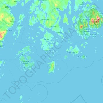
Name: Topografische Karte Camp Island, Höhe, Relief.
Durchschnittliche Höhe: 12 m
Minimale Höhe: -2 m
Maximale Höhe: 461 m
Andere topografische Karten
Klicken Sie auf eine Karte, um ihre Topografie, ihre Höhe und ihr Relief anzuzeigen.
Carrabassett Valley
United States of America > Maine > Carrabassett Valley
Carrabassett Valley, Franklin County, Maine, 04947, United States of America
Durchschnittliche Höhe: 573 m
Turtle Island
United States of America > Maine
Turtle Island, Androscoggin County, Maine, 04228, United States of America
Durchschnittliche Höhe: 151 m
Pretty Marsh
United States of America > Maine > Pretty Marsh
Pretty Marsh, Hancock County, Maine, 04674, United States of America
Durchschnittliche Höhe: 22 m
Crescent Lake
United States of America > Maine > Crescent Lake
Crescent Lake, Cumberland County, Maine, United States of America
Durchschnittliche Höhe: 151 m
Aroostook County
United States of America > Maine
Madawaska Township, Aroostook County, Maine, United States of America
Durchschnittliche Höhe: 222 m
Keegan
United States of America > Maine > Keegan
Keegan, Van Buren, Van Buren Township, Aroostook County, Maine, 04785, United States of America
Durchschnittliche Höhe: 157 m
Levant
United States of America > Maine > Levant
Levant, Penobscot County, Maine, 04450, United States of America
Durchschnittliche Höhe: 48 m
Bald Peak
United States of America > Maine
Bald Peak, Hancock County, Maine, 04662, United States of America
Durchschnittliche Höhe: 193 m
Zion Hill
United States of America > Maine > Chesterville
Zion Hill, Chesterville, Franklin County, Maine, United States of America
Durchschnittliche Höhe: 140 m