
Topografische Karte Calingasta
Interaktive Karte
Klicken Sie auf die Karte, um die Höhe anzuzeigen.
Über diese Karte
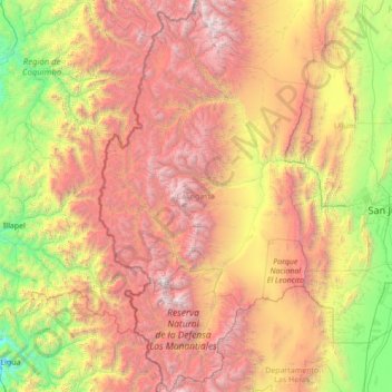
Name: Topografische Karte Calingasta, Höhe, Relief.
Ort: Calingasta, San Juan, Argentina (-32.62663 -70.56968 -30.26862 -69.10017)
Durchschnittliche Höhe: 2.393 m
Minimale Höhe: 74 m
Maximale Höhe: 6.583 m
Calingasta has a rugged, hilly topography due to its location is at the foot of the Andes. The mountain Mercedario is the eighth-highest mountain of the Andes with an altitude of 6,720 metres (22,050 ft). It is located 100 kilometres (62 mi) north of Aconcagua. It is possible to highlight an area precordillerana lower height as the first with numerous mountain cave highlight the Sierra del Tontal. The soil is mainly desert with little vegetation cover except on the river banks in the valleys.
Andere topografische Karten
Klicken Sie auf eine Karte, um ihre Topografie, ihre Höhe und ihr Relief anzuzeigen.
Villa San Andrés
Villa San Andrés, Capital, San Juan, Argentina
Durchschnittliche Höhe: 661 m
Ischigualasto Provincial Park
Ischigualasto Provincial Park, Valle Fértil, San Juan, Argentina
Durchschnittliche Höhe: 1.258 m
Quebrada Seca
Quebrada Seca, Iglesia, San Juan, Argentina
Durchschnittliche Höhe: 4.334 m
Hediondo (o Rincón del Diablo)
Hediondo (o Rincón del Diablo), Iglesia, San Juan, Argentina
Durchschnittliche Höhe: 4.025 m
Parkinson Hill
Parkinson Hill, Zonda, San Juan, 5478, Argentina
Durchschnittliche Höhe: 1.336 m
Quebrada Seca
Quebrada Seca, Calingasta, San Juan, Argentina
Durchschnittliche Höhe: 3.106 m
Cerro Mercedario
Cerro Mercedario, Calingasta, San Juan, Argentina
Durchschnittliche Höhe: 6.128 m