
Topografische Karte Municipio Roma XII
Interaktive Karte
Klicken Sie auf die Karte, um die Höhe anzuzeigen.
Über diese Karte
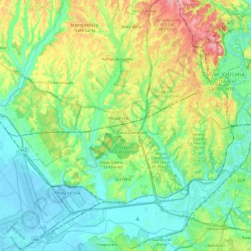
Name: Topografische Karte Municipio Roma XII, Höhe, Relief.
Ort: Municipio Roma XII, Rome, RM, Lazio, Italy (41.83650 12.23691 41.90830 12.47490)
Durchschnittliche Höhe: 45 m
Minimale Höhe: -3 m
Maximale Höhe: 147 m
Andere topografische Karten
Klicken Sie auf eine Karte, um ihre Topografie, ihre Höhe und ihr Relief anzuzeigen.
Palatine Hill
Palatine Hill, Rome, RM, Lazio, 00184, Italy
Durchschnittliche Höhe: 40 m
Municipio Roma VII
Municipio Roma VII, Rome, RM, Lazio, Italy
Durchschnittliche Höhe: 83 m
Municipio Roma I
Municipio Roma I, Rome, RM, Lazio, Italy
Durchschnittliche Höhe: 51 m