
Topografische Karte Rondekop
Interaktive Karte
Klicken Sie auf die Karte, um die Höhe anzuzeigen.
Über diese Karte
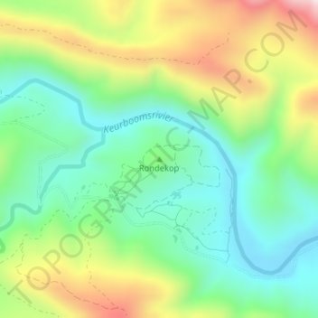
Name: Topografische Karte Rondekop, Höhe, Relief.
Durchschnittliche Höhe: 491 m
Minimale Höhe: 313 m
Maximale Höhe: 810 m
Andere topografische Karten
Klicken Sie auf eine Karte, um ihre Topografie, ihre Höhe und ihr Relief anzuzeigen.
George
South Africa > Western Cape > Garden Route District Municipality > George Local Municipality
George, George Local Municipality, Garden Route District Municipality, Western Cape, 6530, South Africa
Durchschnittliche Höhe: 244 m
Swart River
South Africa > Western Cape > Garden Route District Municipality > George Local Municipality
Swart River, George Local Municipality, Garden Route District Municipality, Western Cape, South Africa
Durchschnittliche Höhe: 342 m
Skurwekop
South Africa > Western Cape > Garden Route District Municipality > George Local Municipality
Skurwekop, George Local Municipality, Garden Route District Municipality, Western Cape, South Africa
Durchschnittliche Höhe: 849 m
Skurweberg
South Africa > Western Cape > Garden Route District Municipality > George Local Municipality
Skurweberg, George Local Municipality, Garden Route District Municipality, Western Cape, South Africa
Durchschnittliche Höhe: 971 m
Garden Route Dam
South Africa > Western Cape > Garden Route District Municipality > George Local Municipality
Garden Route Dam, Glenwood, George Ward 11, George Local Municipality, Garden Route District Municipality, Western Cape, 6546, South Africa
Durchschnittliche Höhe: 201 m
Uniondale
South Africa > Western Cape > Garden Route District Municipality > George Local Municipality
Uniondale, George Local Municipality, Garden Route District Municipality, Western Cape, 6460, South Africa
Durchschnittliche Höhe: 847 m