
Topografische Karte Mesnil-Saint-Père
Interaktive Karte
Klicken Sie auf die Karte, um die Höhe anzuzeigen.
Über diese Karte
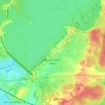
Name: Topografische Karte Mesnil-Saint-Père, Höhe, Relief.
Durchschnittliche Höhe: 140 m
Minimale Höhe: 118 m
Maximale Höhe: 172 m
La superficie de la commune est de 1 745 hectares ; son altitude varie entre 132 et 171 mètres.
Andere topografische Karten
Klicken Sie auf eine Karte, um ihre Topografie, ihre Höhe und ihr Relief anzuzeigen.
Charrey
France > Grand Est > Aube > Marolles-sous-Lignières
Charrey, Marolles-sous-Lignières, Troyes, Aube, Grand Est, France métropolitaine, 10130, France
Durchschnittliche Höhe: 147 m
Ervy-le-Châtel
Ervy-le-Châtel, Troyes, Aube, Grand Est, France métropolitaine, 10130, France
Durchschnittliche Höhe: 139 m
Rue du Moulin
France > Grand Est > Aube > Argançon
Rue du Moulin, Argançon, Bar-sur-Aube, Aube, Grand Est, France métropolitaine, 10140, France
Durchschnittliche Höhe: 215 m
Saint-Nicolas-la-Chapelle
Saint-Nicolas-la-Chapelle, Nogent-sur-Seine, Aube, Grand Est, France métropolitaine, 10400, France
Durchschnittliche Höhe: 91 m
Voie des Brebis
France > Grand Est > Aube > Cussangy
Voie des Brebis, Cussangy, Troyes, Aube, Grand Est, France métropolitaine, 10210, France
Durchschnittliche Höhe: 187 m
Rigny-le-Ferron
Rigny-le-Ferron, Troyes, Aube, Grand Est, France métropolitaine, 10160, France
Durchschnittliche Höhe: 168 m
Arrentières
Arrentières, Bar-sur-Aube, Aube, Grand Est, France métropolitaine, 10200, France
Durchschnittliche Höhe: 268 m
Le Village
France > Grand Est > Aube > Fouchères
Le Village, Fouchères, Troyes, Aube, Grand Est, France métropolitaine, 10260, France
Durchschnittliche Höhe: 151 m
Lusigny-sur-Barse
Lusigny-sur-Barse, Troyes, Aube, Grand Est, France métropolitaine, 10270, France
Durchschnittliche Höhe: 128 m
Landreville
France > Grand Est > Aube > Landreville > Landreville
Landreville, Troyes, Aube, Grand Est, France métropolitaine, 10110, France
Durchschnittliche Höhe: 219 m
Nogent-sur-Seine
Nogent-sur-Seine, Aube, Grand Est, France métropolitaine, 10400, France
Durchschnittliche Höhe: 73 m
Landreville
Landreville, Troyes, Aube, Grand Est, France métropolitaine, 10110, France
Durchschnittliche Höhe: 232 m