
Spenden
Topografische Karte Phetchabun Province
Klicken Sie auf die Karte, um die Höhe anzuzeigen.
Spenden
Über diese Karte
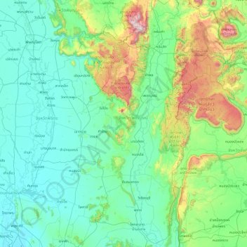
Name: Topografische Karte Phetchabun Province, Höhe, Relief.
Ort: Phetchabun Province, Thailand (15.31830 100.63297 17.17800 101.79725)
Durchschnittliche Höhe: 266 m
Minimale Höhe: 16 m
Maximale Höhe: 1.754 m
Spenden
Andere topografische Karten
Klicken Sie auf eine Karte, um ihre Topografie, ihre Höhe und ihr Relief anzuzeigen.
Spenden
Khon Kaen
Khon Kaen is on the Khorat Plateau, elevation 187 m, and is the center of the mid-northeastern provincial group of Thailand, according to the Thai government. Its coordinates are 16°26′N 102°50′E / 16.433°N 102.833°E / 16.433; 102.833. The city municipality has a population of 114,459, while…
Durchschnittliche Höhe: 165 m
Spenden
Spenden
Spenden
Spenden
Spenden
Spenden
Spenden
Spenden
Spenden
Spenden
Spenden
Phu Kradung
Thailand > Phu Kradueng District
Phu Kradueng National Park (Thai: อุทยานแห่งชาติภูกระดึง), in the Si Than sub-district of Amphoe Phu Kradueng, Loei Province, is a national park in Thailand. It has a high point of 1,316 m (4318 ft) elevation at Khok Moei. It was proclaimed a national park on 23…
Durchschnittliche Höhe: 1.183 m
Spenden
Spenden
Spenden
Pha Dok Siew Waterfall
Thailand > Chom Thong District > Mae Klang Luang
Durchschnittliche Höhe: 1.217 m
Spenden
Spenden
Spenden
Spenden
Spenden
Spenden
Spenden
Prachuap Khiri Khan
Thailand > Mueang Prachuap Khiri Khan
Prachuap Khiri Khan covers an area totaling 6,367 square kilometers (2,458 sq mi). The province is on the Kra Isthmus, the narrow land bridge connecting the Malay Peninsula with mainland Asia. The province has one of the narrowest parts of Thailand, just 12.38 km (7.69 mi) from the Gulf of Thailand to the…
Durchschnittliche Höhe: 9 m
Doi Inthanon
In 1954, the forests around Doi Inthanon were conserved, creating Doi Inthanon National Park, as one of the original 14 national parks of Thailand. This park now covers 482.4 km2 and spreads from the lowlands at 800 metres (2,625 ft) elevation up to the peak at 2,565 metres (8,415 ft). Given the varied…
Durchschnittliche Höhe: 2.364 m
Spenden
Mae Salong
Thailand > Mae Fa Luang > Mae Fa Luang district
Mae Salong is a hilltop village in the Mae Fa Luang district of Thailand's Chiang Rai Province, about 80 kilometres (50 mi) from Chiang Rai. Mae Salong is on the highest peak of the Doi Mae Salong range of mountains, at an elevation of 1,134 metres (3,722 ft) above sea level. It has an alpine-like climate,…
Durchschnittliche Höhe: 1.035 m
Spenden
Spenden