
Topografische Karte Mecklenburg County
Interaktive Karte
Klicken Sie auf die Karte, um die Höhe anzuzeigen.
Über diese Karte
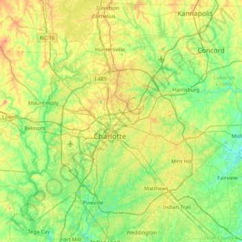
Name: Topografische Karte Mecklenburg County, Höhe, Relief.
Ort: Mecklenburg County, North Carolina, USA (35.00172 -81.05821 35.51480 -80.55030)
Durchschnittliche Höhe: 208 m
Minimale Höhe: 142 m
Maximale Höhe: 373 m
Andere topografische Karten
Klicken Sie auf eine Karte, um ihre Topografie, ihre Höhe und ihr Relief anzuzeigen.
Boone Fork
Boone Fork, Watauga County, North Carolina, 28648, USA
Durchschnittliche Höhe: 1.217 m
Chapel Hill
USA > North Carolina > Chapel Hill
Chapel Hill, Orange County, North Carolina, USA
Durchschnittliche Höhe: 125 m
Mount Mitchell
Mount Mitchell, Yancey County, North Carolina, USA
Durchschnittliche Höhe: 1.743 m
Marshall
USA > North Carolina > Marshall
Marshall, Madison County, North Carolina, USA
Durchschnittliche Höhe: 609 m
Downs Mountain
Downs Mountain, Macon County, North Carolina, 28763, USA
Durchschnittliche Höhe: 732 m
Haywood County
Haywood County, North Carolina, USA
Durchschnittliche Höhe: 1.045 m
Southern Nantahala Wilderness
Southern Nantahala Wilderness, Appalachian Trail, Macon County, North Carolina, USA
Durchschnittliche Höhe: 957 m
Bachelor Creek
Bachelor Creek, Jones County, North Carolina, USA
Durchschnittliche Höhe: 13 m
Appalachians
Appalachians, Yancey County, North Carolina, USA
Durchschnittliche Höhe: 1.463 m