
Vielen Dank für die Unterstützung dieser Website ❤️
Spenden
Spenden
Topografische Karte Mount Banahaw
Klicken Sie auf die Karte, um die Höhe anzuzeigen.
Vielen Dank für die Unterstützung dieser Website ❤️
Spenden
Spenden
Mount Banahaw
The andesitic Banahaw volcanic complex is composed of several stratovolcanoes with Mount Banahaw, the largest with a maximum elevation of 2,170 metres (7,119 ft) above mean sea level. The summit is topped by a 1.5 by 3.5 kilometres (0.93 mi × 2.17 mi) and 210 metres (690 ft) deep crater that is breached on the southern rim believed to have been caused by the 1730 eruption. Prior to 1730, a lake occupied the summit crater of Mount Banahaw. The resulting flood destroyed the town of Sariaya, Quezon located below the mountain.
Vielen Dank für die Unterstützung dieser Website ❤️
Spenden
Spenden
Über diese Karte
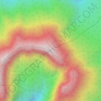
Name: Topografische Karte Mount Banahaw, Höhe, Relief.
Durchschnittliche Höhe: 1.730 m
Minimale Höhe: 1.261 m
Maximale Höhe: 2.145 m
Vielen Dank für die Unterstützung dieser Website ❤️
Spenden
Spenden