
Vielen Dank für die Unterstützung dieser Website ❤️
Spenden
Spenden
Topografische Karte Fonthill
Klicken Sie auf die Karte, um die Höhe anzuzeigen.
Vielen Dank für die Unterstützung dieser Website ❤️
Spenden
Spenden
Über diese Karte
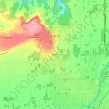
Name: Topografische Karte Fonthill, Höhe, Relief.
Durchschnittliche Höhe: 193 m
Minimale Höhe: 146 m
Maximale Höhe: 260 m
Vielen Dank für die Unterstützung dieser Website ❤️
Spenden
Spenden
Andere topografische Karten
Klicken Sie auf eine Karte, um ihre Topografie, ihre Höhe und ihr Relief anzuzeigen.
Niagara Escarpment
Canada > Ontario > Niagara Region > Lincoln > Vineland
Durchschnittliche Höhe: 148 m
St. Catharines
Canada > Ontario > Niagara Region
The most defining transportation icon of St. Catharines is the Welland Canal, a ship canal that runs 43.4 kilometres (27.0 mi), passing through the city. Four of its locks are within city boundaries. The canal allows shipping vessels to traverse the 99.5-metre (326.5 ft) drop in altitude from Lake Erie to Lake…
Durchschnittliche Höhe: 103 m
Vielen Dank für die Unterstützung dieser Website ❤️
Spenden
Spenden