Geolokalisieren
👉 Easily get elevation data in JSON, GeoTIFF and KML formats using Elevation API
Vielen Dank für die Unterstützung dieser Website ❤️
Spenden

Topografische Karte Liberty

Klicken Sie auf die Karte, um die Höhe anzuzeigen.

👉 Easily get elevation data in JSON, GeoTIFF and KML formats using Elevation API
Vielen Dank für die Unterstützung dieser Website ❤️
Spenden

Über diese Karte

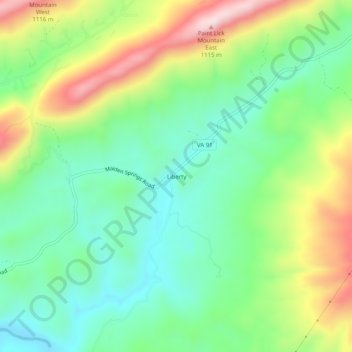
Name: Topografische Karte Liberty, Höhe, Relief.

Ort: Liberty, Tazewell County, Virginia, United States (37.03678 -81.67400 37.07678 -81.63400)

Durchschnittliche Höhe: 832 m

Minimale Höhe: 687 m

Maximale Höhe: 1.092 m

👉 Easily get elevation data in JSON, GeoTIFF and KML formats using Elevation API
Vielen Dank für die Unterstützung dieser Website ❤️
Spenden

Andere topografische Karten

Klicken Sie auf eine Karte, um ihre Topografie, ihre Höhe und ihr Relief anzuzeigen.

Cedar Bluff

United States > Virginia > Tazewell County

Durchschnittliche Höhe: 673 m

Abbs Valley

United States > Virginia > Tazewell County > Abbs Valley

Durchschnittliche Höhe: 859 m

Gratton

United States > Virginia > Tazewell County > Gratton

Durchschnittliche Höhe: 959 m

Abbs Valley

United States > Virginia > Tazewell County > Abbs Valley

Durchschnittliche Höhe: 859 m

Vielen Dank für die Unterstützung dieser Website ❤️
Spenden

Bluefield

United States > Virginia > Tazewell County

Durchschnittliche Höhe: 849 m

Cedar Bluff

United States > Virginia > Tazewell County

Durchschnittliche Höhe: 673 m