
Spenden
Topografische Karte Wagner
Klicken Sie auf die Karte, um die Höhe anzuzeigen.
Spenden
Über diese Karte
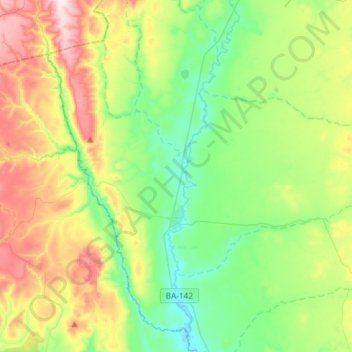
Name: Topografische Karte Wagner, Höhe, Relief.
Durchschnittliche Höhe: 615 m
Minimale Höhe: 426 m
Maximale Höhe: 986 m
Spenden
Andere topografische Karten
Klicken Sie auf eine Karte, um ihre Topografie, ihre Höhe und ihr Relief anzuzeigen.
Chapada Diamantina
The Chapada Diamantina lies at the center of Bahia State and forms the northern part of the Espinhaço Mountain Range. The region is approximately 38,000 km2 (15,000 sq mi) in area and encompasses 58 municipalities. Technically, this region is considered a part of the caatinga biome, and contains some of its…
Durchschnittliche Höhe: 1.390 m
Costa do Sauípe
Brazil > Bahia > Região Metropolitana de Salvador > Mata de São João
Durchschnittliche Höhe: 10 m
Spenden
Chapada Diamantina
The Chapada Diamantina lies at the center of Bahia State and forms the northern part of the Espinhaço Mountain Range. The region is approximately 38,000 km2 (15,000 sq mi) in area and encompasses 58 municipalities. Technically, this region is considered a part of the caatinga biome, and contains some of its…
Durchschnittliche Höhe: 1.390 m
Praia do Forte
Brazil > Bahia > Região Metropolitana de Salvador > Mata de São João
Durchschnittliche Höhe: 5 m
Spenden
Chapada Diamantina
The Chapada Diamantina lies at the center of Bahia State and forms the northern part of the Espinhaço Mountain Range. The region is approximately 38,000 km2 (15,000 sq mi) in area and encompasses 58 municipalities. Technically, this region is considered a part of the caatinga biome, and contains some of its…
Durchschnittliche Höhe: 1.390 m
Spenden
Serra do Cipó
Brazil > Bahia > Região Metropolitana de Feira de Santana > Ipecaetá
Durchschnittliche Höhe: 254 m
Campos
Brazil > Bahia > Região Administrativa Integrada de Desenvolvimento do Polo Petrolina e Juazeiro > Juazeiro
Durchschnittliche Höhe: 387 m
Spenden
Spenden