
Topografische Karte Aegean
Interaktive Karte
Klicken Sie auf die Karte, um die Höhe anzuzeigen.
Über diese Karte
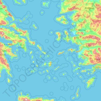
Name: Topografische Karte Aegean, Höhe, Relief.
Ort: Aegean, Greece (35.23795 24.06581 40.10085 29.72970)
Durchschnittliche Höhe: 124 m
Minimale Höhe: -2 m
Maximale Höhe: 2.305 m
Andere topografische Karten
Klicken Sie auf eine Karte, um ihre Topografie, ihre Höhe und ihr Relief anzuzeigen.
Municipality of Andros
Greece > Aegean > Andros Regional Unit
Municipality of Andros, Andros Regional Unit, South Aegean, Aegean, Greece
Durchschnittliche Höhe: 83 m
Santorini
Greece > Aegean > Thira Municipal Unit
Santorini, Thira Municipal Unit, Municipality of Thira, Thira Regional Unit, South Aegean, Aegean, Greece
Durchschnittliche Höhe: 30 m
Emporio
Greece > Aegean > Thira Regional Unit > Thira Municipal Unit > Emporio
Emporio, Thira Municipal Unit, Municipality of Thira, Thira Regional Unit, South Aegean, Aegean, 84703, Greece
Durchschnittliche Höhe: 116 m
Municipality of Kos
Greece > Aegean > Municipality of Kos
Municipality of Kos, Kos Regional Unit, South Aegean, Aegean, Greece
Durchschnittliche Höhe: 32 m
Panteli
Greece > Aegean > Vromolithos
Panteli, Vromolithos, Δήμος Λέρου, Kalmynos Regional Unit, South Aegean Region, Aegean, 854 00, Greece
Durchschnittliche Höhe: 33 m
Thira Municipal Unit
Greece > Aegean > Thira Regional Unit
Thira Municipal Unit, Municipality of Thira, Thira Regional Unit, South Aegean, Aegean, Greece
Durchschnittliche Höhe: 12 m
Notio Aspronisi West
Notio Aspronisi West, Δήμος Λειψών, Kalmynos Regional Unit, South Aegean Region, Aegean, Greece
Durchschnittliche Höhe: 2 m