
Topografische Karte Durieu
Interaktive Karte
Klicken Sie auf die Karte, um die Höhe anzuzeigen.
Über diese Karte
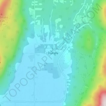
Name: Topografische Karte Durieu, Höhe, Relief.
Durchschnittliche Höhe: 142 m
Minimale Höhe: 2 m
Maximale Höhe: 832 m
Andere topografische Karten
Klicken Sie auf eine Karte, um ihre Topografie, ihre Höhe und ihr Relief anzuzeigen.
Stave Lake
Canada > British Columbia > Area F (McConnell Creek/Hatzic Prairie)
Stave Lake, Area F (McConnell Creek/Hatzic Prairie), British Columbia, Canada
Durchschnittliche Höhe: 576 m
Kenyon Lake
Canada > British Columbia > Area F (McConnell Creek/Hatzic Prairie)
Kenyon Lake, Area F (McConnell Creek/Hatzic Prairie), British Columbia, Canada
Durchschnittliche Höhe: 765 m
Golden Ears Park
Canada > British Columbia > Area F (McConnell Creek/Hatzic Prairie)
Golden Ears Park, Area F (McConnell Creek/Hatzic Prairie), Fraser Valley Regional District, British Columbia, Canada
Durchschnittliche Höhe: 1.292 m
Golden Ears
Canada > British Columbia > Area F (McConnell Creek/Hatzic Prairie)
Golden Ears, Area F (McConnell Creek/Hatzic Prairie), British Columbia, Canada
Durchschnittliche Höhe: 1.119 m
Alligator Point
Canada > British Columbia > Area F (McConnell Creek/Hatzic Prairie)
Alligator Point, Area F (McConnell Creek/Hatzic Prairie), British Columbia, Canada
Durchschnittliche Höhe: 174 m