
Topografische Karte Parque Juárez
Interaktive Karte
Klicken Sie auf die Karte, um die Höhe anzuzeigen.
Über diese Karte
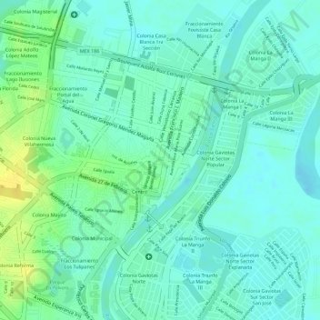
Name: Topografische Karte Parque Juárez, Höhe, Relief.
Ort: Parque Juárez, Villahermosa, Centro, Tabasco, México (17.99084 -92.91802 17.99130 -92.91715)
Durchschnittliche Höhe: 10 m
Minimale Höhe: 1 m
Maximale Höhe: 26 m
Andere topografische Karten
Klicken Sie auf eine Karte, um ihre Topografie, ihre Höhe und ihr Relief anzuzeigen.
Parque Mario Trujillo
México > Tabasco > Centro > Villahermosa
Parque Mario Trujillo, Colonia José Narciso Rovirosa, Villahermosa, Centro, Tabasco, México
Durchschnittliche Höhe: 16 m
Parque Fracc. Deportiva
México > Tabasco > Centro > Villahermosa
Parque Fracc. Deportiva, Sector 3, Villahermosa, Centro, Tabasco, México
Durchschnittliche Höhe: 17 m
Laguna De Las Ilusiones
México > Tabasco > Centro > Villahermosa
Laguna De Las Ilusiones, Villahermosa, Centro, Tabasco, México
Durchschnittliche Höhe: 11 m