
Topografische Karte Tullin
Interaktive Karte
Klicken Sie auf die Karte, um die Höhe anzuzeigen.
Über diese Karte
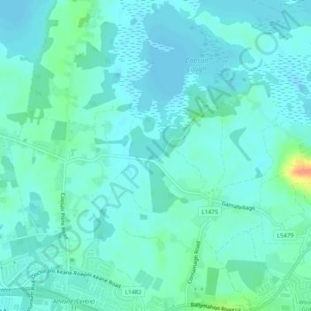
Name: Topografische Karte Tullin, Höhe, Relief.
Durchschnittliche Höhe: 42 m
Minimale Höhe: 34 m
Maximale Höhe: 79 m
Andere topografische Karten
Klicken Sie auf eine Karte, um ihre Topografie, ihre Höhe und ihr Relief anzuzeigen.
Mullingar
Mullingar, The Municipal District of Mullingar — Kinnegad, County Westmeath, Comté de Westmeath, Leinster, Irlande
Durchschnittliche Höhe: 99 m
Derry
Derry, Castlelost ED, The Municipal District of Mullingar — Kinnegad, County Westmeath, Comté de Westmeath, Leinster, N91 AE6P, Irlande
Durchschnittliche Höhe: 84 m
Portloman ED
Portloman ED, The Municipal District of Athlone — Moate, County Westmeath, Comté de Westmeath, Leinster, Irlande
Durchschnittliche Höhe: 100 m
The Municipal District of Mullingar — Kinnegad
The Municipal District of Mullingar — Kinnegad, County Westmeath, Comté de Westmeath, Leinster, Irlande
Durchschnittliche Höhe: 90 m
Athlone
Irlande > County Westmeath > Athlone
Athlone, The Municipal District of Athlone — Moate, County Westmeath, Leinster, N37 N1F2, Irlande
Durchschnittliche Höhe: 44 m