
Topografische Karte Kampala
Interaktive Karte
Klicken Sie auf die Karte, um die Höhe anzuzeigen.
Über diese Karte
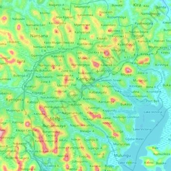
Name: Topografische Karte Kampala, Höhe, Relief.
Ort: Kampala, Central Region, Uganda (0.21436 32.50988 0.40577 32.66874)
Durchschnittliche Höhe: 1.179 m
Minimale Höhe: 1.128 m
Maximale Höhe: 1.315 m
Kampala is a hilly place with its valleys filled with sluggish rivers/ swamps. The highest point in the city proper is the summit of Kololo hill at 1,311 metres (4,301 ft), located in the center of the city and the lowest point at the shores of Lake Victoria south of the city center at altitude of 1,135 metres (3,724 ft).
Andere topografische Karten
Klicken Sie auf eine Karte, um ihre Topografie, ihre Höhe und ihr Relief anzuzeigen.
Universal
Uganda > Central Region > Kampala
Universal, Kampala, Central Region, Uganda
Durchschnittliche Höhe: 1.184 m
Central
Uganda > Central Region > Kampala
Central, Kampala, Central Region, Uganda
Durchschnittliche Höhe: 1.193 m