
Topografische Karte Žilina
Interaktive Karte
Klicken Sie auf die Karte, um die Höhe anzuzeigen.
Über diese Karte
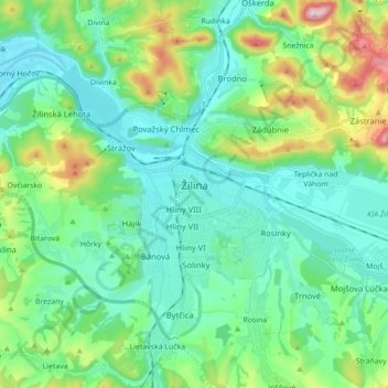
Name: Topografische Karte Žilina, Höhe, Relief.
Durchschnittliche Höhe: 424 m
Minimale Höhe: 314 m
Maximale Höhe: 792 m
Žilina lies at an altitude of 342 metres (1,122 ft) above sea level and covers an area of 80.03 square kilometres (30.9 sq mi). It is located in the Upper Váh region (Slovak: Horné Považie) at the confluence of three rivers: Váh, flowing from the east into the south-west, Kysuca, flowing from the north and Rajčanka rivers from the south, in the Žilina Basin. The city is surrounded by these mountain ranges: Malá Fatra, Súľovské vrchy, Javorníky and Kysucká vrchovina. Protected areas nearby include the Strážov Mountains Protected Landscape Area, the Kysuce Protected Landscape Area, and the Malá Fatra National Park. There are two hydroelectric dams on the Váh river around Žilina: the Žilina dam in the east and the Hričov dam in the west.
Andere topografische Karten
Klicken Sie auf eine Karte, um ihre Topografie, ihre Höhe und ihr Relief anzuzeigen.
Turky
Slovakia > Region of Žilina > District of Žilina > Rosina
Turky, Rosina, District of Žilina, Region of Žilina, Central Slovakia, 013 12, Slovakia
Durchschnittliche Höhe: 451 m
Žilina
Slovakia > Region of Žilina > District of Žilina > Žilina
Žilina, District of Žilina, Region of Žilina, Central Slovakia, 01242, Slovakia
Durchschnittliche Höhe: 569 m
Dolný Hričov
Slovakia > Region of Žilina > District of Žilina
Dolný Hričov, District of Žilina, Region of Žilina, Central Slovakia, 013 41, Slovakia
Durchschnittliche Höhe: 435 m
Terchová
Slovakia > Region of Žilina > District of Žilina
Terchová, District of Žilina, Region of Žilina, Central Slovakia, 013 06, Slovakia
Durchschnittliche Höhe: 819 m