
Topografische Karte Beanblossom
Interaktive Karte
Klicken Sie auf die Karte, um die Höhe anzuzeigen.
Über diese Karte
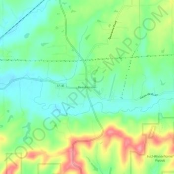
Name: Topografische Karte Beanblossom, Höhe, Relief.
Ort: Beanblossom, Brown County, Indiana, 47435, United States (39.24699 -86.26916 39.28699 -86.22916)
Durchschnittliche Höhe: 233 m
Minimale Höhe: 197 m
Maximale Höhe: 297 m
Andere topografische Karten
Klicken Sie auf eine Karte, um ihre Topografie, ihre Höhe und ihr Relief anzuzeigen.
Helmsburg
United States > Indiana > Brown County
Helmsburg, Brown County, Indiana, 47435, United States
Durchschnittliche Höhe: 222 m
Story
United States > Indiana > Brown County
Story, Brown County, Indiana, United States
Durchschnittliche Höhe: 195 m
Pikes Peak
United States > Indiana > Brown County
Pikes Peak, Brown County, Indiana, United States
Durchschnittliche Höhe: 219 m
Needmore
United States > Indiana > Brown County
Needmore, Brown County, Indiana, 47435, United States
Durchschnittliche Höhe: 223 m
Becks Grove
United States > Indiana > Brown County
Becks Grove, Brown County, Indiana, United States
Durchschnittliche Höhe: 239 m
Christiansburg
United States > Indiana > Brown County
Christiansburg, Brown County, Indiana, United States
Durchschnittliche Höhe: 217 m
Fruitdale
United States > Indiana > Brown County
Fruitdale, Brown County, Indiana, 46160, United States
Durchschnittliche Höhe: 247 m
Camp Roberts
United States > Indiana > Brown County
Camp Roberts, Brown County, Indiana, United States
Durchschnittliche Höhe: 226 m
Cornelius
United States > Indiana > Brown County
Cornelius, Brown County, Indiana, 47435, United States
Durchschnittliche Höhe: 242 m
Clarksdale
United States > Indiana > Brown County
Clarksdale, Brown County, Indiana, United States
Durchschnittliche Höhe: 242 m
Mount Liberty
United States > Indiana > Brown County
Mount Liberty, Brown County, Indiana, United States
Durchschnittliche Höhe: 241 m
Lanam
United States > Indiana > Brown County
Lanam, Brown County, Indiana, 47435, United States
Durchschnittliche Höhe: 242 m
Belmont
United States > Indiana > Brown County
Belmont, Brown County, Indiana, United States
Durchschnittliche Höhe: 196 m
Elkinsville
United States > Indiana > Brown County
Elkinsville, Brown County, Indiana, United States
Durchschnittliche Höhe: 200 m
Gatesville
United States > Indiana > Brown County
Gatesville, Brown County, Indiana, United States
Durchschnittliche Höhe: 238 m
Peoga
United States > Indiana > Brown County
Peoga, Brown County, Indiana, 46164, United States
Durchschnittliche Höhe: 280 m
Gnaw Bone
United States > Indiana > Brown County
Gnaw Bone, Brown County, Indiana, United States
Durchschnittliche Höhe: 231 m
Stone Head
United States > Indiana > Brown County
Stone Head, Brown County, Indiana, United States
Durchschnittliche Höhe: 214 m
Spearsville
United States > Indiana > Brown County
Spearsville, Brown County, Indiana, United States
Durchschnittliche Höhe: 271 m
Kirkofer Lake Dam
United States > Indiana > Brown County
Kirkofer Lake Dam, Brown County, Indiana, United States
Durchschnittliche Höhe: 241 m
Trevlac
United States > Indiana > Brown County
Trevlac, Brown County, Indiana, 47435, United States
Durchschnittliche Höhe: 214 m
Taggart
United States > Indiana > Brown County
Taggart, Brown County, Indiana, United States
Durchschnittliche Höhe: 237 m
Nashville
United States > Indiana > Brown County
Nashville, Brown County, Indiana, United States
Durchschnittliche Höhe: 208 m