
Topografische Karte Ballynabortagh
Interaktive Karte
Klicken Sie auf die Karte, um die Höhe anzuzeigen.
Über diese Karte
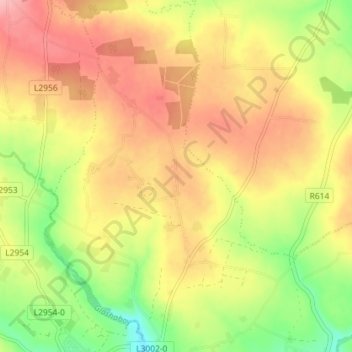
Name: Topografische Karte Ballynabortagh, Höhe, Relief.
Durchschnittliche Höhe: 153 m
Minimale Höhe: 86 m
Maximale Höhe: 208 m
Andere topografische Karten
Klicken Sie auf eine Karte, um ihre Topografie, ihre Höhe und ihr Relief anzuzeigen.
Coosane
Ireland > County Cork > Municipal District of Cobh
Coosane, Watergrasshill, Municipal District of Cobh, County Cork, Munster, Ireland
Durchschnittliche Höhe: 108 m
Lysaghtstown
Ireland > County Cork > Municipal District of Cobh
Lysaghtstown, Carrigtohill ED, Municipal District of Cobh, County Cork, Munster, Ireland
Durchschnittliche Höhe: 81 m
Tullagreen
Ireland > County Cork > Municipal District of Cobh
Tullagreen, Carrigtohill ED, Municipal District of Cobh, County Cork, Munster, Ireland
Durchschnittliche Höhe: 12 m
Ballynanelagh
Ireland > County Cork > Municipal District of Cobh > Knockraha
Ballynanelagh, Knockraha, Municipal District of Cobh, County Cork, Munster, Ireland
Durchschnittliche Höhe: 113 m