
Topografische Karte Cambridge
Interaktive Karte
Klicken Sie auf die Karte, um die Höhe anzuzeigen.
Über diese Karte
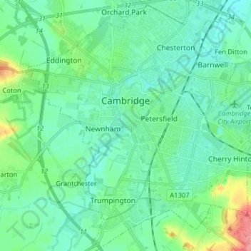
Name: Topografische Karte Cambridge, Höhe, Relief.
Durchschnittliche Höhe: 18 m
Minimale Höhe: 2 m
Maximale Höhe: 80 m
The city, like most of the UK, has a maritime climate highly influenced by the Gulf Stream. Located in the driest region of Britain, Cambridge's rainfall averages around 570 mm (22.44 in) per year, around half the national average, The driest recent year was in 2011 with 380.4 mm (14.98 in) of rain at the Botanic Garden and 347.2 mm (13.67 in) at the NIAB site. This is just below the semi-arid precipitation threshold for the area, which is 350mm of annual precipitation. Conversely, 2012 was the wettest year on record, with 812.7 mm (32.00 in) reported. Snowfall accumulations are usually small, in part because of Cambridge's low elevation, and low precipitation tendency during transitional snow events.
Andere topografische Karten
Klicken Sie auf eine Karte, um ihre Topografie, ihre Höhe und ihr Relief anzuzeigen.
Wisbech
United Kingdom > England > Cambridgeshire > Fenland District
Wisbech, Fenland District, Cambridgeshire, Cambridgeshire and Peterborough, England, United Kingdom
Durchschnittliche Höhe: 3 m
Cambridge
United Kingdom > England > Cambridgeshire > Cambridge
Cambridge, Cambridgeshire, East of England, England, CB2 3NR, United Kingdom
Durchschnittliche Höhe: 33 m