
Topografische Karte Tochal
Interaktive Karte
Klicken Sie auf die Karte, um die Höhe anzuzeigen.
Über diese Karte
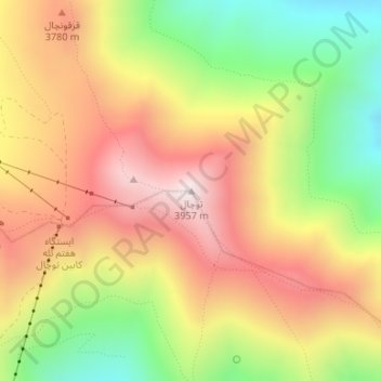
Name: Topografische Karte Tochal, Höhe, Relief.
Ort: Tochal, رودبار قصران, Shemiranat County, Tehran Province, Iran (35.88430 51.41982 35.88440 51.41992)
Durchschnittliche Höhe: 3.562 m
Minimale Höhe: 3.122 m
Maximale Höhe: 3.958 m
Tochal (Persian: توچال Točāl), is a mountain and ski resort located on the Alborz mountain range, adjacent to the metropolitan area of Tehran in northern Iran. It includes a 12-kilometre-long (7.5 mi) ridge. Its highest peak, also called Tochal, is at an elevation of 3,964 metres (13,005 ft).
Andere topografische Karten
Klicken Sie auf eine Karte, um ihre Topografie, ihre Höhe und ihr Relief anzuzeigen.
Rey City
Iran > Tehran Province > Rey City
Rey, Rey City, بخش مرکزی شهرستان ری, Rey County, Tehran Province, 18499, Iran
Durchschnittliche Höhe: 1.075 m
Rey County
Rey City, بخش مرکزی شهرستان ری, Rey County, Tehran Province, Iran
Durchschnittliche Höhe: 1.070 m