
Topografische Karte Villa La Angostura
Interaktive Karte
Klicken Sie auf die Karte, um die Höhe anzuzeigen.
Villa La Angostura
The elevation of the city centre is about 790 m, the lake is at 765 m. Surrounding mountains range from 1,500 m to about 2,000 m (Cerro Bayo, right behind the city, is 1,782 m high).
Über diese Karte
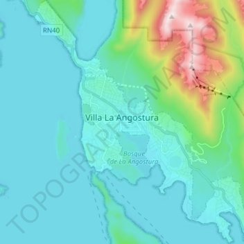
Name: Topografische Karte Villa La Angostura, Höhe, Relief.
Durchschnittliche Höhe: 921 m
Minimale Höhe: 759 m
Maximale Höhe: 1.824 m