
Topografische Karte Hyderabad
Interaktive Karte
Klicken Sie auf die Karte, um die Höhe anzuzeigen.
Über diese Karte
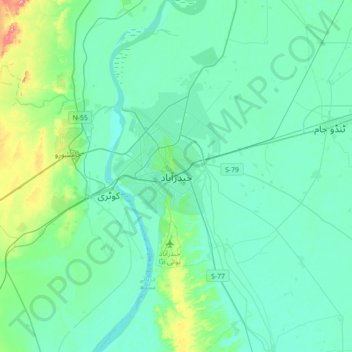
Name: Topografische Karte Hyderabad, Höhe, Relief.
Ort: Hyderabad, , Sindh, 91000, Pakistan (25.22010 68.21504 25.54010 68.53504)
Durchschnittliche Höhe: 28 m
Minimale Höhe: 8 m
Maximale Höhe: 136 m
Located at 25.367 °N latitude and 68.367 °E longitude with an elevation of 13 metres (43 ft), Hyderabad is located on the east bank of the Indus River and is roughly 150 kilometres (93 mi) away from Karachi, the provincial capital. Two of Pakistan's largest highways, the Indus Highway and the National Highway join at Hyderabad. Several towns surrounding the city include Kotri at 6.7 kilometres (4.2 mi), Jamshoro at 8.1 kilometres (5.0 mi), Hattri at 5.0 kilometres (3.1 mi) and Husri at 7.5 kilometres (4.7 mi).