
Topografische Karte West Byfleet
Klicken Sie auf die Karte, um die Höhe anzuzeigen.
West Byfleet
The surface undulates gently from the west to the east, where West Byfleet's land is drained in the parish of Byfleet itself by the River Wey. Soil ranges from sandy acidic soil in the west to more alluvial soil in the east, underlain by a mixture of gravel and clay. Elevations range from 18m Above Ordnance Datum to 33m.
Über diese Karte
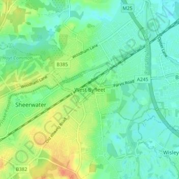
Name: Topografische Karte West Byfleet, Höhe, Relief.
Durchschnittliche Höhe: 26 m
Minimale Höhe: 13 m
Maximale Höhe: 52 m
Andere topografische Karten
Klicken Sie auf eine Karte, um ihre Topografie, ihre Höhe und ihr Relief anzuzeigen.
Horsell Common
United Kingdom > England > Surrey > Woking > Horsell > Durnford Farm
Durchschnittliche Höhe: 29 m
Brookwood Country Park
United Kingdom > England > Surrey > Woking > Knaphill
Durchschnittliche Höhe: 47 m