Geolokalisieren
👉 Easily get elevation data in JSON, GeoTIFF and KML formats using Elevation API
Vielen Dank für die Unterstützung dieser Website ❤️
Spenden

Topografische Karte Kathua

Klicken Sie auf die Karte, um die Höhe anzuzeigen.

👉 Easily get elevation data in JSON, GeoTIFF and KML formats using Elevation API
Vielen Dank für die Unterstützung dieser Website ❤️
Spenden

Über diese Karte

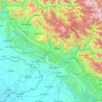
Name: Topografische Karte Kathua, Höhe, Relief.

Ort: Kathua, Jammu and Kashmir, India (31.88333 74.80000 33.28333 76.20000)

Durchschnittliche Höhe: 1.162 m

Minimale Höhe: 223 m

Maximale Höhe: 5.440 m

👉 Easily get elevation data in JSON, GeoTIFF and KML formats using Elevation API
Vielen Dank für die Unterstützung dieser Website ❤️
Spenden

Andere topografische Karten

Klicken Sie auf eine Karte, um ihre Topografie, ihre Höhe und ihr Relief anzuzeigen.

Ramban District

India > Jammu and Kashmir

Durchschnittliche Höhe: 2.248 m

Handwara tehsil

India > Jammu and Kashmir

Durchschnittliche Höhe: 2.321 m

Warwan Valley

India > Jammu and Kashmir > Marwah > Branyan > Mungil

Durchschnittliche Höhe: 2.732 m

Awantipora

India > Jammu and Kashmir

Durchschnittliche Höhe: 1.665 m

Vielen Dank für die Unterstützung dieser Website ❤️
Spenden

Rafiabad

India > Jammu and Kashmir

Durchschnittliche Höhe: 1.863 m

Kathua district

India > Jammu and Kashmir

Greek historians, who provide an insight into the ancient history of Jammu hills, prominently record the existence in this area of two powerful empires - Abhisara (present day Poonch) and Kathaioi - at the time of invasion of India by Alexander. Strabo describes Kathaioi as a mighty republic of that…

Durchschnittliche Höhe: 1.144 m

Chadoora

India > Jammu and Kashmir

Durchschnittliche Höhe: 1.702 m

Kulgam

India > Jammu and Kashmir

Durchschnittliche Höhe: 2.697 m

Vielen Dank für die Unterstützung dieser Website ❤️
Spenden

Banihal

India > Jammu and Kashmir

Durchschnittliche Höhe: 2.478 m

Bishnah

India > Jammu and Kashmir

Durchschnittliche Höhe: 296 m

Majalta

India > Jammu and Kashmir

Durchschnittliche Höhe: 846 m

Akhnoor

India > Jammu and Kashmir

Durchschnittliche Höhe: 429 m

Vielen Dank für die Unterstützung dieser Website ❤️
Spenden

Ranbir Singh Pora

India > Jammu and Kashmir

Durchschnittliche Höhe: 268 m

Atholi (Paddar)

India > Jammu and Kashmir

Durchschnittliche Höhe: 4.338 m

Gandoh

India > Jammu and Kashmir

Durchschnittliche Höhe: 2.864 m

Devsar

India > Jammu and Kashmir

Durchschnittliche Höhe: 1.676 m

Vielen Dank für die Unterstützung dieser Website ❤️
Spenden

Bijbehara

India > Jammu and Kashmir

Durchschnittliche Höhe: 1.700 m

Lar

India > Jammu and Kashmir

Durchschnittliche Höhe: 1.995 m

Srinagar (South)

India > Jammu and Kashmir

Durchschnittliche Höhe: 1.593 m

Srinagar (North)

India > Jammu and Kashmir

Durchschnittliche Höhe: 2.097 m

Vielen Dank für die Unterstützung dieser Website ❤️
Spenden

Boniyar

India > Jammu and Kashmir

Durchschnittliche Höhe: 2.525 m

Kreeri

India > Jammu and Kashmir

Durchschnittliche Höhe: 2.325 m

Hiranagar

India > Jammu and Kashmir

Durchschnittliche Höhe: 404 m

Bani

India > Jammu and Kashmir

Durchschnittliche Höhe: 2.300 m

Vielen Dank für die Unterstützung dieser Website ❤️
Spenden

Billawar

India > Jammu and Kashmir

Durchschnittliche Höhe: 1.305 m

Bhaderwah

India > Jammu and Kashmir

Durchschnittliche Höhe: 2.511 m

Ramnagar

India > Jammu and Kashmir

Durchschnittliche Höhe: 1.790 m

Jammu district

India > Jammu and Kashmir

Durchschnittliche Höhe: 608 m

Vielen Dank für die Unterstützung dieser Website ❤️
Spenden

Srinagar

India > Jammu and Kashmir

Durchschnittliche Höhe: 2.366 m

Pahalgam

India > Jammu and Kashmir

Durchschnittliche Höhe: 3.265 m

Anantnag

India > Jammu and Kashmir

Anantnag is located at 33°44′N 75°09′E / 33.73°N 75.15°E / 33.73; 75.15, at an elevation of 5,300 feet (1,600 m) above sea level, at a distance of 53 kilometres (33 mi) from Srinagar on NH 44 (former name NH 1A before renumbering of all national highways).

Durchschnittliche Höhe: 1.724 m

Kathua

India > Jammu and Kashmir

Durchschnittliche Höhe: 498 m

Vielen Dank für die Unterstützung dieser Website ❤️
Spenden

Udhampur district

India > Jammu and Kashmir

Temperature varies considerably in the Udhampur District, as the altitude ranges from 600–3,000 metres (2,000–9,800 ft). Chenab, Ans, Tawi and Ujh are the main rivers. The district is rich in minerals such as coal, bauxite, gypsum and limestone.

Durchschnittliche Höhe: 1.483 m

Rajouri District

India > Jammu and Kashmir

Durchschnittliche Höhe: 1.238 m

Chenani

India > Jammu and Kashmir

Durchschnittliche Höhe: 1.812 m

Bandipora

India > Jammu and Kashmir

Durchschnittliche Höhe: 2.703 m

Vielen Dank für die Unterstützung dieser Website ❤️
Spenden

Rajauri

India > Jammu and Kashmir

Durchschnittliche Höhe: 1.415 m

Gurez

India > Jammu and Kashmir

Durchschnittliche Höhe: 3.702 m

Gool-Gulabgarh

India > Jammu and Kashmir

Durchschnittliche Höhe: 2.190 m

Chhatroo

India > Jammu and Kashmir

Durchschnittliche Höhe: 2.868 m

Vielen Dank für die Unterstützung dieser Website ❤️
Spenden

Thathri

India > Jammu and Kashmir

Durchschnittliche Höhe: 2.057 m

Sonawari

India > Jammu and Kashmir

Durchschnittliche Höhe: 1.791 m

Kalakote

India > Jammu and Kashmir

Durchschnittliche Höhe: 954 m

Darhal

India > Jammu and Kashmir

Durchschnittliche Höhe: 1.991 m

Vielen Dank für die Unterstützung dieser Website ❤️
Spenden

Thanamandi

India > Jammu and Kashmir

Durchschnittliche Höhe: 1.708 m

Sunderbani

India > Jammu and Kashmir

Durchschnittliche Höhe: 646 m

Budhal

India > Jammu and Kashmir

Durchschnittliche Höhe: 1.770 m

Kangan

India > Jammu and Kashmir

Durchschnittliche Höhe: 3.328 m

Vielen Dank für die Unterstützung dieser Website ❤️
Spenden

Pattan

India > Jammu and Kashmir

Durchschnittliche Höhe: 1.619 m

Shopian

India > Jammu and Kashmir

Durchschnittliche Höhe: 2.525 m

Marwah

India > Jammu and Kashmir

Durchschnittliche Höhe: 4.017 m

Tral

India > Jammu and Kashmir

Durchschnittliche Höhe: 2.528 m

Vielen Dank für die Unterstützung dieser Website ❤️
Spenden

Kashmir Division

India > Jammu and Kashmir

Durchschnittliche Höhe: 2.674 m

Tangmarg

India > Jammu and Kashmir

Durchschnittliche Höhe: 2.777 m

Shopian

India > Jammu and Kashmir

Durchschnittliche Höhe: 2.525 m

Doda

India > Jammu and Kashmir

The climate of the area is not uniform due to its wide variations in altitude. The area, in general, enjoys a temperate to sub-tropical climate. The climate of the district is almost dry and rainfall is scanty. The temperature varies from place to place. Ramban and Doda tehsils are warmer, while regions like…

Durchschnittliche Höhe: 2.302 m

Vielen Dank für die Unterstützung dieser Website ❤️
Spenden

Budgam

India > Jammu and Kashmir

Durchschnittliche Höhe: 2.401 m

Uri

India > Jammu and Kashmir

Durchschnittliche Höhe: 2.144 m

Reasi

India > Jammu and Kashmir

Durchschnittliche Höhe: 994 m

Pulwama

India > Jammu and Kashmir

Durchschnittliche Höhe: 2.143 m

Vielen Dank für die Unterstützung dieser Website ❤️
Spenden

Ganderbal

India > Jammu and Kashmir

Furthermore, Durinar Lake III (located at an elevation of 4,650 meters above sea level) is the highest altitude alpine lake in Kashmir, while Manasbal Lake (with a depth of 13 meters or 43 feet) is the deepest plain lake in Kashmir. Both lakes fall within the jurisdiction of the Ganderbal district.

Durchschnittliche Höhe: 3.094 m

Latti Dhuna

India > Jammu and Kashmir > Ramnagar

Durchschnittliche Höhe: 1.855 m

Ladakh Range

India > Jammu and Kashmir > Leh

Durchschnittliche Höhe: 4.936 m

Dal Lake

India > Jammu and Kashmir > Srīnagar > Srinagar

The average elevation of the lake is 1,583 metres (5,194 ft). The depth of water varies from 6 metres (20 ft) at its deepest in Nigeen lake to 2.5 metres (8.2 ft), the shallowest at Gagribal. The depth ratio between the maximum and minimum depths varies with the season between 0.29 and 0.25, which is…

Durchschnittliche Höhe: 1.715 m

Vielen Dank für die Unterstützung dieser Website ❤️
Spenden

Kokernag

India > Jammu and Kashmir > Kokernag

Durchschnittliche Höhe: 2.646 m

Jhajjar Nala

India > Jammu and Kashmir > Jammu > Domel

Durchschnittliche Höhe: 559 m

Vishansar

India > Jammu and Kashmir > Gurez

Durchschnittliche Höhe: 3.858 m

Asnoor

India > Jammu and Kashmir > Damhal Hanjipora

Durchschnittliche Höhe: 2.193 m

Vielen Dank für die Unterstützung dieser Website ❤️
Spenden

Pir Panjal Range

India > Jammu and Kashmir > Mandi tehsil

Durchschnittliche Höhe: 3.285 m

Kulgam

India > Jammu and Kashmir > Kulgam

Durchschnittliche Höhe: 1.732 m

Surinsar Lake

India > Jammu and Kashmir > Jammu

Durchschnittliche Höhe: 577 m

Ratnipora

India > Jammu and Kashmir > Pulwama tehsil

Durchschnittliche Höhe: 1.592 m

Vielen Dank für die Unterstützung dieser Website ❤️
Spenden

MAGAM

India > Jammu and Kashmir > Tangmarg

Durchschnittliche Höhe: 1.592 m

Harwan Garden

India > Jammu and Kashmir > Srinagar (North)

Durchschnittliche Höhe: 1.739 m

Bathnoor

India > Jammu and Kashmir > Tral

Durchschnittliche Höhe: 2.132 m

Mirhama

India > Jammu and Kashmir > Kulgam

Durchschnittliche Höhe: 1.805 m

Vielen Dank für die Unterstützung dieser Website ❤️
Spenden

Ganderbal

India > Jammu and Kashmir

Ganderbal district, with its district headquarters located at 33°44′N 75°09′E / 33.73°N 75.15°E / 33.73; 75.15, at an average elevation of 1,950 metres (6,400 ft) above sea level, at a distance of 21 kilometres (13 mi) from Srinagar city.

Durchschnittliche Höhe: 3.094 m

Kishtwar

India > Jammu and Kashmir

The Kishtwar–Anantnag National Highway passes through the Sinthan Pass and Daksum Nowpachi Road passes through the Margan top a 13 km long and 5100-metre-high pass. The Steep Brahma mountain peak is situated at Dachhan which is documented by British mountaineers. The Warwan Valley has been rated among…

Durchschnittliche Höhe: 3.650 m

Kulgam

India > Jammu and Kashmir

The main source of livelihood in the district is agriculture and horticulture. The low-lying areas of Kulgam are very fertile for rice cultivation, and are considered as the 'Rice Bowl of Kashmir'. The higher elevations are known for production of apples. Livestock and sheep-rearing is a subsidiary occupation…

Durchschnittliche Höhe: 2.681 m

Gandoh

India > Jammu and Kashmir

Durchschnittliche Höhe: 2.864 m

Vielen Dank für die Unterstützung dieser Website ❤️
Spenden

Nillow

India > Jammu and Kashmir > Kulgam

Durchschnittliche Höhe: 1.824 m

Udhampur

India > Jammu and Kashmir

Temperature varies considerably in the Udhampur District, as the altitude ranges from 600–3,000 metres (2,000–9,800 ft). Chenab, Ans, Tawi and Ujh are the main rivers. The district is rich in minerals such as coal, bauxite, gypsum and limestone.

Durchschnittliche Höhe: 1.483 m

Kupwara District

India > Jammu and Kashmir

Durchschnittliche Höhe: 2.540 m

Dooru tehsil

India > Jammu and Kashmir

Durchschnittliche Höhe: 2.297 m

Vielen Dank für die Unterstützung dieser Website ❤️
Spenden

TRC Park

India > Jammu and Kashmir > Srinagar (South) > Srinagar

Durchschnittliche Höhe: 1.594 m

Kupwara District

India > Jammu and Kashmir

Durchschnittliche Höhe: 2.540 m

Rafiabad

India > Jammu and Kashmir

Durchschnittliche Höhe: 1.863 m

Chhatroo

India > Jammu and Kashmir

Durchschnittliche Höhe: 2.868 m

Vielen Dank für die Unterstützung dieser Website ❤️
Spenden

Pahalgam

India > Jammu and Kashmir

Durchschnittliche Höhe: 3.271 m

Noorpora (Geur)

India > Jammu and Kashmir > Awantipora

Durchschnittliche Höhe: 1.622 m

Anantnag

India > Jammu and Kashmir

Anantnag is located at 33°44′N 75°09′E / 33.73°N 75.15°E / 33.73; 75.15, at an elevation of 5,300 feet (1,600 m) above sea level, at a distance of 53 kilometres (33 mi) from Srinagar on NH 44 (former name NH 1A before renumbering of all national highways).

Durchschnittliche Höhe: 1.724 m

Shangus

India > Jammu and Kashmir > Shangus

Durchschnittliche Höhe: 2.451 m

Vielen Dank für die Unterstützung dieser Website ❤️
Spenden

Dooru

India > Jammu and Kashmir > Dooru

Durchschnittliche Höhe: 2.297 m

Dal Lake

India > Jammu and Kashmir > Srīnagar > Srinagar

The average elevation of the lake is 1,583 metres (5,194 ft). The depth of water varies from 6 metres (20 ft) at its deepest in Nigeen lake to 2.5 metres (8.2 ft), the shallowest at Gagribal. The depth ratio between the maximum and minimum depths varies with the season between 0.29 and 0.25, which is…

Durchschnittliche Höhe: 1.715 m

Gurez

India > Jammu and Kashmir

Durchschnittliche Höhe: 3.703 m

Mandi tehsil

India > Jammu and Kashmir

Durchschnittliche Höhe: 2.862 m

Vielen Dank für die Unterstützung dieser Website ❤️
Spenden

Doda

India > Jammu and Kashmir

The climate of the area is not uniform due to its wide variations in altitude. The area, in general, enjoys a temperate to sub-tropical climate. The climate of the district is almost dry and rainfall is scanty. The temperature varies from place to place. Ramban and Doda tehsils are warmer, while regions like…

Durchschnittliche Höhe: 2.302 m

MAGAM

India > Jammu and Kashmir > Tangmarg

Durchschnittliche Höhe: 1.592 m

Sunderbani

India > Jammu and Kashmir

Durchschnittliche Höhe: 646 m

Ramnagar

India > Jammu and Kashmir

Durchschnittliche Höhe: 1.790 m

Vielen Dank für die Unterstützung dieser Website ❤️
Spenden