
Topografische Karte Mount Morgan
Interaktive Karte
Klicken Sie auf die Karte, um die Höhe anzuzeigen.
Über diese Karte
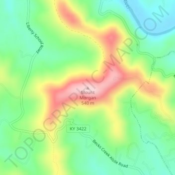
Name: Topografische Karte Mount Morgan, Höhe, Relief.
Ort: Mount Morgan, Whitley County, Kentucky, 40769, USA (36.74392 -84.19471 36.74402 -84.19461)
Durchschnittliche Höhe: 374 m
Minimale Höhe: 274 m
Maximale Höhe: 530 m
Andere topografische Karten
Klicken Sie auf eine Karte, um ihre Topografie, ihre Höhe und ihr Relief anzuzeigen.
Sugar Loaf Mountain
Sugar Loaf Mountain, Fleming County, Kentucky, USA
Durchschnittliche Höhe: 259 m
Spring Hill
USA > Kentucky > Spring Hill
Spring Hill, Hickman County, Kentucky, USA
Durchschnittliche Höhe: 121 m
Gardenside
USA > Kentucky > Gardenside
Gardenside, Fayette County, Kentucky, 40504, USA
Durchschnittliche Höhe: 293 m
Little Georgetown
USA > Kentucky > Little Georgetown
Little Georgetown, Fayette County, Kentucky, 40513, USA
Durchschnittliche Höhe: 285 m
Mount Washington
USA > Kentucky > Mount Washington
Mount Washington, Bullitt County, Kentucky, 40047, USA
Durchschnittliche Höhe: 184 m