Geolokalisieren
👉 Easily get elevation data in JSON, GeoTIFF and KML formats using Elevation API
Vielen Dank für die Unterstützung dieser Website ❤️
Spenden

Topografische Karte Sirao

Klicken Sie auf die Karte, um die Höhe anzuzeigen.

👉 Easily get elevation data in JSON, GeoTIFF and KML formats using Elevation API
Vielen Dank für die Unterstützung dieser Website ❤️
Spenden

Über diese Karte

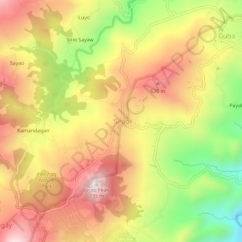
Name: Topografische Karte Sirao, Höhe, Relief.

Ort: Sirao, Cebu City, Central Visayas, Philippines (10.39413 123.85221 10.43413 123.89221)

Durchschnittliche Höhe: 455 m

Minimale Höhe: 114 m

Maximale Höhe: 726 m

👉 Easily get elevation data in JSON, GeoTIFF and KML formats using Elevation API
Vielen Dank für die Unterstützung dieser Website ❤️
Spenden

Andere topografische Karten

Klicken Sie auf eine Karte, um ihre Topografie, ihre Höhe und ihr Relief anzuzeigen.

Fort San Pedro

Philippines > Cebu City

Durchschnittliche Höhe: 3 m

Cebu South Road Properties

Philippines > Cebu City

Durchschnittliche Höhe: 2 m

Kamputhaw River

Philippines > Cebu City

Durchschnittliche Höhe: 68 m

SM Tower

Philippines > Cebu City

Durchschnittliche Höhe: 3 m

Vielen Dank für die Unterstützung dieser Website ❤️
Spenden

Kotkot River

Philippines > Cebu City

Durchschnittliche Höhe: 316 m

San Roque

Philippines > Cebu City

Durchschnittliche Höhe: 4 m

Butuanon River

Philippines > Cebu City

Durchschnittliche Höhe: 44 m

Hippodromo Park

Philippines > Cebu City

Durchschnittliche Höhe: 13 m

Vielen Dank für die Unterstützung dieser Website ❤️
Spenden

Pari-an

Philippines > Cebu City

Durchschnittliche Höhe: 8 m

TIEZA Pond

Philippines > Cebu City > Malubog

Durchschnittliche Höhe: 471 m

Guadalupe River

Philippines > Cebu City

Durchschnittliche Höhe: 220 m

Butuanon River

Philippines > Cebu City

Durchschnittliche Höhe: 105 m

Vielen Dank für die Unterstützung dieser Website ❤️
Spenden

Bulacao River

Philippines > Cebu City > To-ong

Durchschnittliche Höhe: 203 m

Hipodromo

Philippines > Cebu City

Durchschnittliche Höhe: 16 m

Bulacao River

Philippines > Cebu City > To-ong

Durchschnittliche Höhe: 203 m

Mahiga Creek

Philippines > Cebu City

Durchschnittliche Höhe: 22 m

Vielen Dank für die Unterstützung dieser Website ❤️
Spenden

Talamban

Philippines > Cebu City

Durchschnittliche Höhe: 61 m

Butuanon River

Philippines > Cebu City

Durchschnittliche Höhe: 41 m

Butuanon River

Philippines > Cebu City

Durchschnittliche Höhe: 85 m

Sambag I

Philippines > Cebu City

Durchschnittliche Höhe: 14 m

Vielen Dank für die Unterstützung dieser Website ❤️
Spenden

Butuanon River

Philippines > Cebu City

Durchschnittliche Höhe: 230 m

CBP Central Park

Philippines > Cebu City

Durchschnittliche Höhe: 19 m

Buhisan Dam

Philippines > Cebu City > To-ong > Puti

Durchschnittliche Höhe: 221 m

Vielen Dank für die Unterstützung dieser Website ❤️
Spenden

Mananga River

Philippines > Cebu City > Buot

Durchschnittliche Höhe: 351 m