
Topografische Karte Union County
Interaktive Karte
Klicken Sie auf die Karte, um die Höhe anzuzeigen.
Über diese Karte
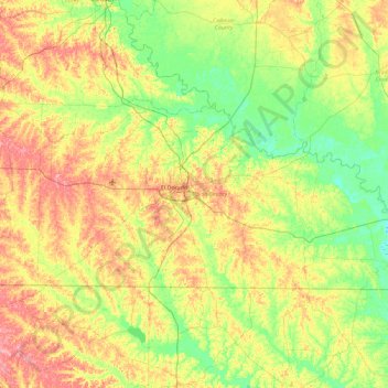
Name: Topografische Karte Union County, Höhe, Relief.
Ort: Union County, Arkansas, USA (33.00802 -92.98870 33.38788 -92.06900)
Durchschnittliche Höhe: 53 m
Minimale Höhe: 14 m
Maximale Höhe: 118 m
Andere topografische Karten
Klicken Sie auf eine Karte, um ihre Topografie, ihre Höhe und ihr Relief anzuzeigen.
Ozark Plateau
Ozark Plateau, Coburn Loop, Clark County, Arkansas, USA
Durchschnittliche Höhe: 51 m
Moorefield
USA > Arkansas > Moorefield
Moorefield, Independence County, Arkansas, USA
Durchschnittliche Höhe: 109 m
Holly Springs
USA > Arkansas > Holly Springs
Holly Springs, Pulaski County, Arkansas, USA
Durchschnittliche Höhe: 169 m
Battlefield
USA > Arkansas > Battlefield
Battlefield, Hempstead County, Arkansas, USA
Durchschnittliche Höhe: 92 m
Pilgrims Rest
USA > Arkansas > Pilgrims Rest
Pilgrims Rest, Washington County, Arkansas, USA
Durchschnittliche Höhe: 384 m