Geolokalisieren
👉 Easily get elevation data in JSON, GeoTIFF and KML formats using Elevation API
Vielen Dank für die Unterstützung dieser Website ❤️
Spenden

Topografische Karte Beypore

Klicken Sie auf die Karte, um die Höhe anzuzeigen.

👉 Easily get elevation data in JSON, GeoTIFF and KML formats using Elevation API
Vielen Dank für die Unterstützung dieser Website ❤️
Spenden

Beypore

Beypore is located at 11°11′N 75°49′E / 11.18°N 75.82°E / 11.18; 75.82. It has an average elevation of one metre (3 ft 3 in).

Wikipedia (CC-BY-SA 3.0)

👉 Easily get elevation data in JSON, GeoTIFF and KML formats using Elevation API
Vielen Dank für die Unterstützung dieser Website ❤️
Spenden

Über diese Karte

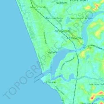
Name: Topografische Karte Beypore, Höhe, Relief.

Ort: Beypore, Kozhikode, Kerala, 673015, India (11.13907 75.77018 11.21907 75.85018)

Durchschnittliche Höhe: 8 m

Minimale Höhe: -2 m

Maximale Höhe: 57 m

👉 Easily get elevation data in JSON, GeoTIFF and KML formats using Elevation API
Vielen Dank für die Unterstützung dieser Website ❤️
Spenden

Andere topografische Karten

Klicken Sie auf eine Karte, um ihre Topografie, ihre Höhe und ihr Relief anzuzeigen.

Kottooli

India > Kerala > Kozhikode > Thondayad > Pottammal

Durchschnittliche Höhe: 18 m

Sarovaram Bio Park

India > Kerala > Kozhikode > Erenjippalam

Durchschnittliche Höhe: 14 m

Karuvissery

India > Kerala > Kozhikode > Erenjippalam

Durchschnittliche Höhe: 17 m

Palliyol pothu Kulam

India > Kerala > Kozhikode > Mavoor

Durchschnittliche Höhe: 26 m

Vielen Dank für die Unterstützung dieser Website ❤️
Spenden

Kuttichira

India > Kerala > Kozhikode > Kozhikode

Durchschnittliche Höhe: 8 m

Mavoor

India > Kerala > Kozhikode > Alin chuvadu

Durchschnittliche Höhe: 20 m

Chalappuram

India > Kerala > Kozhikode > Kozhikode

Durchschnittliche Höhe: 12 m

Mananchira

India > Kerala > Kozhikode > Kozhikode

Durchschnittliche Höhe: 12 m

Vielen Dank für die Unterstützung dieser Website ❤️
Spenden

Eranhipalam

India > Kerala > Kozhikode > Erenjippalam

Durchschnittliche Höhe: 14 m

Chaliyar River

India > Kerala > Kozhikode > Kolathara Chungam

Durchschnittliche Höhe: 29 m

Pazhamparamb

India > Kerala > Kozhikode > Koolimadu > Cheruvadi

Durchschnittliche Höhe: 26 m

Oloppara

India > Kerala > Kozhikode > Chelannur > Chirattatu colony

Durchschnittliche Höhe: 20 m

Vielen Dank für die Unterstützung dieser Website ❤️
Spenden

Malaparamba

India > Kerala > Kozhikode > Eranhipalam

Durchschnittliche Höhe: 17 m

Iruvazhinji

India > Kerala > Kozhikode

Durchschnittliche Höhe: 44 m

Thali Temple

India > Kerala > Kozhikode > Nanminda 13th Mile

Durchschnittliche Höhe: 36 m

Paimbalassery

India > Kerala > Kozhikode

Durchschnittliche Höhe: 39 m

Vielen Dank für die Unterstützung dieser Website ❤️
Spenden

Olavanna

India > Kerala > Kozhikode > Pantheerankave

Durchschnittliche Höhe: 19 m

Kallayi

India > Kerala > Kozhikode > Kozhikode

Durchschnittliche Höhe: 13 m