
Topografische Karte Banks County
Interaktive Karte
Klicken Sie auf die Karte, um die Höhe anzuzeigen.
Über diese Karte
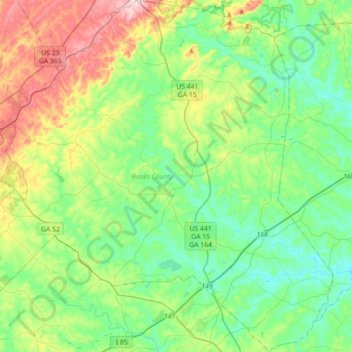
Name: Topografische Karte Banks County, Höhe, Relief.
Ort: Banks County, Georgia, USA (34.19750 -83.66967 34.49154 -83.33785)
Durchschnittliche Höhe: 271 m
Minimale Höhe: 187 m
Maximale Höhe: 477 m
Andere topografische Karten
Klicken Sie auf eine Karte, um ihre Topografie, ihre Höhe und ihr Relief anzuzeigen.
Beaufort Island
Beaufort Island, Screven County, Georgia, USA
Durchschnittliche Höhe: 49 m
Cameron Point
USA > Georgia > Cameron Point
Cameron Point, Hall County, Georgia, 30506:30534, USA
Durchschnittliche Höhe: 339 m
Ferrell Crossroads
USA > Georgia > Ferrell Crossroads
Ferrell Crossroads, Early County, Georgia, USA
Durchschnittliche Höhe: 94 m
Arabia Mountain
USA > Georgia > Stonecrest
Arabia Mountain, Stonecrest, DeKalb County, Georgia, 30058-8829, USA
Durchschnittliche Höhe: 255 m
Hidden Creek
Hidden Creek, Douglas County, Georgia, 30135, USA
Durchschnittliche Höhe: 286 m