
Topografische Karte Warrenwood
Interaktive Karte
Klicken Sie auf die Karte, um die Höhe anzuzeigen.
Über diese Karte
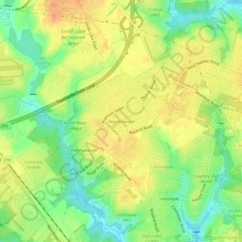
Name: Topografische Karte Warrenwood, Höhe, Relief.
Durchschnittliche Höhe: 64 m
Minimale Höhe: 40 m
Maximale Höhe: 84 m
Andere topografische Karten
Klicken Sie auf eine Karte, um ihre Topografie, ihre Höhe und ihr Relief anzuzeigen.
Kirkwood
United States > North Carolina > Cumberland County > Fayetteville
Kirkwood, Fayetteville, Cumberland County, North Carolina, 28303, United States
Durchschnittliche Höhe: 66 m
Atlantic Coastal Plain
United States > North Carolina > Cumberland County > Fayetteville
Atlantic Coastal Plain, Fayetteville, Cumberland County, North Carolina, 28304, United States
Durchschnittliche Höhe: 51 m
Edenroc
United States > North Carolina > Cumberland County > Fayetteville > Edenroc
Edenroc, Fayetteville, Cumberland County, North Carolina, 28305, United States
Durchschnittliche Höhe: 57 m