
Topografische Karte Hunter’s Point South Waterfront Park
Interaktive Karte
Klicken Sie auf die Karte, um die Höhe anzuzeigen.
Über diese Karte
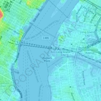
Name: Topografische Karte Hunter’s Point South Waterfront Park, Höhe, Relief.
Durchschnittliche Höhe: 5 m
Minimale Höhe: -9 m
Maximale Höhe: 61 m
Andere topografische Karten
Klicken Sie auf eine Karte, um ihre Topografie, ihre Höhe und ihr Relief anzuzeigen.
Central Park
United States > New York > New York County > New York
Central Park, New York County, New York, United States
Durchschnittliche Höhe: 26 m
Manhattan
United States > New York > New York County > New York
Manhattan, New York County, New York, United States
Durchschnittliche Höhe: 16 m
Governors Island
United States > New York > New York County > New York
Governors Island, Manhattan, New York County, New York, United States
Durchschnittliche Höhe: 1 m
Battery Park
United States > New York > New York County > New York
Battery Park, Financial District, Manhattan, New York County, New York, 10004, United States
Durchschnittliche Höhe: 3 m
Highbridge Park
United States > New York > New York County > New York
Highbridge Park, Manhattan, New York County, New York, United States
Durchschnittliche Höhe: 30 m
Manhattan Community Board 3
United States > New York > New York County > New York
Manhattan Community Board 3, Manhattan, New York County, New York, United States, Seward Park
Durchschnittliche Höhe: 10 m
Roosevelt Island
United States > New York > New York County > New York
Roosevelt Island, Manhattan, New York County, New York, 10044, United States
Durchschnittliche Höhe: 13 m