
Spenden
Topografische Karte Bozeman
Klicken Sie auf die Karte, um die Höhe anzuzeigen.
Spenden
Bozeman
Bozeman is located at an elevation of 4,820 feet (1,470 m). The Bridger Mountains are to the north-northeast, the Tobacco Root Mountains to the west-southwest, the Big Belt Mountains and Horseshoe Hills to the northwest, the Hyalite Peaks of the northern Gallatin Range to the south and the Spanish Peaks of the northern Madison Range to the south-southwest. Bozeman is east of the continental divide, and Interstate 90 passes through the city. It is 84 miles (135 km) east of Butte, 125 miles (201 km) west of Billings, and 93 miles (150 km) north of Yellowstone National Park.
Spenden
Über diese Karte
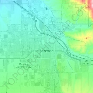
Name: Topografische Karte Bozeman, Höhe, Relief.
Ort: Bozeman, Gallatin County, Montana, United States (45.63479 -111.11982 45.73326 -110.98424)
Durchschnittliche Höhe: 1.495 m
Minimale Höhe: 1.392 m
Maximale Höhe: 1.974 m
Spenden
Andere topografische Karten
Klicken Sie auf eine Karte, um ihre Topografie, ihre Höhe und ihr Relief anzuzeigen.
Gallatin Gateway
United States > Montana > Gallatin County
Gallatin Gateway is a census-designated place (CDP) in Gallatin County, Montana, United States. As of the 2020 census, Gallatin Gateway had a population of 967. Elevation is 4,953 ft (1,510 m).
Durchschnittliche Höhe: 1.519 m
Spenden
Spenden
Bozeman
United States > Montana > Gallatin County > Bozeman
Bozeman is located at an elevation of 4,820 feet (1,470 m). The Bridger Mountains are to the north-northeast, the Tobacco Root Mountains to the west-south-west, the Big Belt Mountains and Horseshoe Hills to the northwest, the Hyalite Peaks of the northern Gallatin Range to the south and the Spanish Peaks of…
Durchschnittliche Höhe: 1.679 m