
Spenden
Topografische Karte Azilal Province
Klicken Sie auf die Karte, um die Höhe anzuzeigen.
Spenden
Über diese Karte
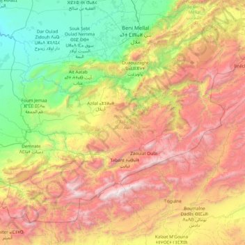
Name: Topografische Karte Azilal Province, Höhe, Relief.
Ort: Azilal Province, Béni Mellal-Khénifra, Morocco (31.33899 -7.32114 32.40285 -5.79858)
Durchschnittliche Höhe: 1.621 m
Minimale Höhe: 322 m
Maximale Höhe: 3.971 m
Spenden
Andere topografische Karten
Klicken Sie auf eine Karte, um ihre Topografie, ihre Höhe und ihr Relief anzuzeigen.
Atlas Mountains
Morocco > cercle de Taliouine > Toubkal ⵜⵓⴱⵇⴰⵍ توبقال
The Atlas Mountains are a mountain range in the Maghreb in North Africa. It separates the Sahara Desert from the Mediterranean Sea and the Atlantic Ocean; the name "Atlantic" is derived from the mountain range, which stretches around 2,500 km (1,600 mi) through Morocco, Algeria and Tunisia. The range's highest…
Durchschnittliche Höhe: 3.402 m
Marrakesh
Morocco > Pachalik de Marrakech > Marrakesh
By road, Marrakesh is located 580 kilometres (360 mi) southwest of Tangier, 327 kilometres (203 mi) southwest of the Moroccan capital of Rabat, 239 kilometres (149 mi) southwest of Casablanca, 196 kilometres (122 mi) southwest of Beni Mellal, 177 kilometres (110 mi) east of Essaouira, and 246 kilometres (153…
Durchschnittliche Höhe: 485 m
Ifni Lake
Morocco > Souss-Massa > Cercle de Taliouine > Toubkal ⵜⵓⴱⵇⴰⵍ توبقال
Durchschnittliche Höhe: 2.593 m
Douar Jadid F.B.S
Morocco > Béni Mellal-Khénifra > cercle de Fquih Ben Salah دائرة الفقيه بن صالح
Durchschnittliche Höhe: 425 m
Spenden
Parc Écologique d'Oujda
Morocco > Oriental > Pachalik d'Oujda باشوية وجدة > Oujda
Durchschnittliche Höhe: 511 m
Toubkal
Morocco > Marrakech-Safi > Cercle d'Asni > Asni
Toubkal, also Jbel Toubkal or Jebel Toubkal, is a mountain in southwestern Morocco, located in the Toubkal National Park. At 4,167 m (13,671 ft), it is the highest peak in Morocco, the Atlas Mountains, North Africa and the Arab world. Located 63 km (39 mi) south of the city of Marrakesh, and visible from it,…
Durchschnittliche Höhe: 3.616 m
Spenden
Spenden
Ksar Taguersift
Morocco > Drâa-Tafilalet > Cercle d'Agdz > Tamezmoute تامزموت
Durchschnittliche Höhe: 904 m
Tamezmoute
Morocco > Drâa-Tafilalet > Cercle d'Agdz > Tamezmoute تامزموت
Durchschnittliche Höhe: 906 m
Spenden
Ouzina
Morocco > Drâa-Tafilalet > Cercle d'Er-Rissani > Et-taous ⵟⴰⵡⵙ الطاوس
Durchschnittliche Höhe: 665 m
Spenden
Aït Benhaddou
Morocco > Drâa-Tafilalet > Cercle d'Amerzgane دائرة أمرزكان > Ait Zineb
Durchschnittliche Höhe: 1.318 m
Spenden
Parque del Marxán
Morocco > Tangier-Tetouan-Al Hoceima > Pachalik de Tanger باشوية طنجة > Tangier
Durchschnittliche Höhe: 29 m
Spenden
Rmilet
Morocco > Tangier-Tetouan-Al Hoceima > Pachalik de Tanger باشوية طنجة > Tanger طنجة
Durchschnittliche Höhe: 112 m
Dchar Ouattah مدشر وطاح
Morocco > Tangier-Tetouan-Al Hoceima > Cercle de Loukous > Tatoft
Durchschnittliche Höhe: 138 m
Beni Habbane
Morocco > Cercle d'Oujda-Banlieue nord دائرة وجدة-الضاحية الشمالية > Ain Sfa
Durchschnittliche Höhe: 859 m
Spenden
Spenden
Mghayer
Morocco > Tangier-Tetouan-Al Hoceima > Pachalik de Tanger باشوية طنجة > Tangier
Durchschnittliche Höhe: 93 m
Oukaïmeden
Morocco > Marrakech-Safi > Cercle de Tahannaout دائرة تحناوت > Oukaimeden
The skiing area is at an altitude of between 2,600 metres (8,500 ft) and 3,200 metres (10,500 ft) and has six ski lifts. There are some hotels and ski rental facilities nearby. Recently oukaimeden is more known of it’s Bouldering potential then the skiing possibilities.
Durchschnittliche Höhe: 2.422 m
Spenden
Atlas Mountains
Morocco > cercle de Taliouine > Toubkal ⵜⵓⴱⵇⴰⵍ توبقال
The Atlas Mountains are a mountain range in the Maghreb in North Africa. It separates the Sahara Desert from the Mediterranean Sea and the Atlantic Ocean; the name "Atlantic" is derived from the mountain range, which stretches around 2,500 km (1,600 mi) through Morocco, Algeria and Tunisia. The range's highest…
Durchschnittliche Höhe: 3.402 m
Spenden
Sidi Addi
Morocco > cercle d'Azrou دائرة أزرو > Sidi El Makhfi سيدي المخفي
Durchschnittliche Höhe: 1.116 m
Setti Fatma
Morocco > Cercle de Tahannaout دائرة تحناوت > Sti Fadma > Sti Fadma
Durchschnittliche Höhe: 1.874 m
Spenden
Agoudal ou Souss
Morocco > Souss-Massa > Pachalik d'Ait Meloul ⵍⴱⴰⵛⴰⵡⵉⵢⴰ ⵏ ⴰⵢⵜ ⵎⴻⵍⵍⵓⵍ باشوية ايت ملول > Aït Melloul
Durchschnittliche Höhe: 29 m
Spenden
Anfa Park منتزه أنفا
Morocco > Pachalik de Casablanca باشوية الدار البيضاء > Casablanca
Durchschnittliche Höhe: 50 m
Aïn Almou ⵄⵉⵏ ⴰⵍⵎⵓ عين ألمو
Morocco > Cercle d'Oujda-Banlieue nord دائرة وجدة-الضاحية الشمالية > Ain Sfa
Durchschnittliche Höhe: 1.285 m
Spenden
Amellagou
Morocco > Cercle de Goulmima دائرة كلميمة > Amellagou املاكو
Durchschnittliche Höhe: 1.353 m
Tanammert
Morocco > Marrakech-Safi > cercle d'Imintanout > Lalla Aaziza > Igrnsouk
Durchschnittliche Höhe: 1.108 m
Agoudal
Morocco > Drâa-Tafilalet > Cercle d'Imilchil > Bou Azmou بوازمو
Durchschnittliche Höhe: 2.408 m
Spenden
Dar Barroud
Morocco > Tangier-Tetouan-Al Hoceima > Pachalik de Tanger باشوية طنجة > Tangier
Durchschnittliche Höhe: 20 m
Oulad Aliane
Morocco > Marrakech-Safi > Cercle de Rehamna > Skhour Rhamna
Durchschnittliche Höhe: 470 m
Haut Atlas Oriental National Park
This site covers 55,252 ha of the High Atlas between Midelt and Er Rachidia. The base rock consists of limestone with some igneous intrusions. The site ranges in altitude from 1,645 m in the bed of the Oued Arheddou to 3,102 m at the summit of Jbel Tanrhourt. At its western end it includes the twin lakes of…
Durchschnittliche Höhe: 1.984 m
Azrou أزرو
Morocco > Oriental > Cercle du Rif Nord دائرة الريف الشمالية > Trougout تروكوت
Durchschnittliche Höhe: 237 m
Spenden
Oued El Ogla
Morocco > Casablanca-Settat > Pachalik de El Mansouria > El Mansouria
Durchschnittliche Höhe: 15 m
Baie de Nekkour
Morocco > Tangier-Tetouan-Al Hoceima > Ajdir أجدير > Sidi Mohamedi
Durchschnittliche Höhe: 21 m
Krimda قريمدة
Morocco > Tangier-Tetouan-Al Hoceima > cercle de Oued El Makhazine دائرة وادي المخازن
Durchschnittliche Höhe: 154 m
Sidi Addi
Morocco > Fez-Meknes > Cercle d'Azrou دائرة أزرو > Sidi El Makhfi سيدي المخفي
Durchschnittliche Höhe: 1.116 m
Spenden
Fontaine de Morroco Mall
Morocco > Pachalik de Casablanca باشوية الدار البيضاء > Casablanca
Durchschnittliche Höhe: 12 m
Tizert
Morocco > Marrakech-Safi > Cercle de Tahannaout دائرة تحناوت > Sti Fadma
Durchschnittliche Höhe: 1.454 m
Quaà Asserasse قـاع أسـراس
Morocco > Tangier-Tetouan-Al Hoceima > Cercle de Bou Ahmed دائرة بو أحمد > Tizgane تزكان
Durchschnittliche Höhe: 74 m
Spenden
Spenden
Amtoudi
Morocco > Guelmim-Oued Noun > cercle de Bouizakarne دائرة بويزكارن > Amtdi ⴰⵎⵟⴹⵉ امطضي
Durchschnittliche Höhe: 1.002 m
Spenden
Amougar-n-Ait Marghad
Morocco > Cercle de Goulmima دائرة كلميمة > Amellagou املاكو
Durchschnittliche Höhe: 1.605 m
Spenden
Spenden
Atlas Mountains
Morocco > cercle de Taliouine > Toubkal ⵜⵓⴱⵇⴰⵍ توبقال
The Atlas Mountains are a mountain range in the Maghreb in North Africa. They separate the Sahara Desert from the Mediterranean Sea and the Atlantic Ocean; the name "Atlantic" is derived from the mountain range, which stretches around 2,500 km (1,600 mi) through Morocco, Algeria and Tunisia. The mountains are…
Durchschnittliche Höhe: 3.402 m
Plage Blanche ⴰⴼⵜⴰⵙ ⴰⵎⵍⵍⴰⵍ الشاطئ الأبيض
Morocco > Cercle de Laqsabi دائرة القصابي > Echatea El Abied الشاطئ الأبيض > Echatea El Abied
Durchschnittliche Höhe: 36 m
Spenden
Jebel Musa
Morocco > Tangier-Tetouan-Al Hoceima > Cercle de tétouan دائرة تطوان > Belyounech
Durchschnittliche Höhe: 353 m
Spenden
Lake Iriki
Morocco > cercle de Foum Zguid دائرة فم زكيد > Allougoum الوڭوم
Durchschnittliche Höhe: 460 m
Jaouna
Morocco > Cercle Driouch Sud دائرة الدريوش الجنوبية > Mtalssa أمطالسة
Durchschnittliche Höhe: 320 m
Spenden