
Topografische Karte Animas Forks
Interaktive Karte
Klicken Sie auf die Karte, um die Höhe anzuzeigen.
Über diese Karte
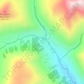
Name: Topografische Karte Animas Forks, Höhe, Relief.
Ort: Animas Forks, San Juan County, Colorado, United States (37.92086 -107.58124 37.94086 -107.56124)
Durchschnittliche Höhe: 3.636 m
Minimale Höhe: 3.282 m
Maximale Höhe: 4.179 m
Animas Forks is located on a system of roads known as the Alpine Loop. The loop is a 65-mile (105 km) system of unpaved roads which connects the small mountain towns of Lake City, Ouray, and Silverton. Most of the land in the area is managed by either the U.S. Forest Service or the Bureau of Land Management. The Alpine Loop is visited by over 100,000 people each year. Animas Forks, at an elevation of 11,200 feet (3,400 m), is more than two miles (3 km) above sea level.
Andere topografische Karten
Klicken Sie auf eine Karte, um ihre Topografie, ihre Höhe und ihr Relief anzuzeigen.
Silverton
United States > Colorado > San Juan County
Silverton, San Juan County, Colorado, 81433, United States
Durchschnittliche Höhe: 2.991 m
Andrews Lake
United States > Colorado > San Juan County
Andrews Lake, San Juan County, Colorado, United States
Durchschnittliche Höhe: 3.312 m