
Spenden
Topografische Karte Galdakao
Klicken Sie auf die Karte, um die Höhe anzuzeigen.
Spenden
Über diese Karte
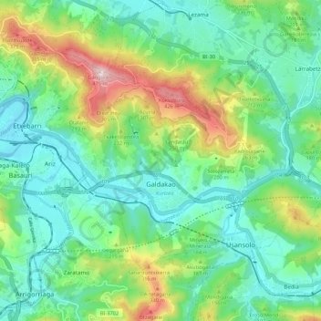
Name: Topografische Karte Galdakao, Höhe, Relief.
Durchschnittliche Höhe: 147 m
Minimale Höhe: 22 m
Maximale Höhe: 466 m
Spenden
Andere topografische Karten
Klicken Sie auf eine Karte, um ihre Topografie, ihre Höhe und ihr Relief anzuzeigen.
Gebara
Spain > Autonomous Community of the Basque Country > Arabako lautada/Llanada Alavesa
Durchschnittliche Höhe: 574 m
Larraitz
Spain > Autonomous Community of the Basque Country > Abaltzisketa
Durchschnittliche Höhe: 477 m
Spenden
Marabi
Spain > Autonomous Community of the Basque Country > Amorebieta-Etxano
Durchschnittliche Höhe: 161 m
Karakate
Spain > Autonomous Community of the Basque Country > Debabarrena > Soraluze
Durchschnittliche Höhe: 366 m
Spenden
Santa Barbara
Spain > Autonomous Community of the Basque Country > Hernani > Sorgintxulo
Durchschnittliche Höhe: 68 m
Soil
Spain > Autonomous Community of the Basque Country > Arabako Mendialdea
Durchschnittliche Höhe: 898 m
Bujal
Spain > Autonomous Community of the Basque Country > Añanako kuadrilla > Berantevilla
Durchschnittliche Höhe: 535 m
Araneta
Spain > Autonomous Community of the Basque Country > Gasteizko kuadrilla/Cuadrilla de Vitoria > Vitoria-Gasteiz > Bolívar
Durchschnittliche Höhe: 625 m
Spenden
Soil
Spain > Autonomous Community of the Basque Country > Montaña Alavesa/Arabako Mendialdea
Durchschnittliche Höhe: 898 m
Makola
Spain > Autonomous Community of the Basque Country > Urola-Kosta > Azkoitia
Durchschnittliche Höhe: 515 m
Fuente Oneri
Spain > Autonomous Community of the Basque Country > Arabako lautada/Llanada Alavesa > Agurain/Salvatierra
Durchschnittliche Höhe: 681 m
Spenden
Iruka
Spain > Autonomous Community of the Basque Country > Debabarrena > Eibar
Durchschnittliche Höhe: 425 m
Torrea
Spain > Autonomous Community of the Basque Country > Debabarrena > Eibar
Durchschnittliche Höhe: 398 m
Flysch
Spain > Autonomous Community of the Basque Country > Urola-Kosta > Zumaia
Durchschnittliche Höhe: 27 m
Barinatxe - La Salvaje
Spain > Autonomous Community of the Basque Country > Sopela
Durchschnittliche Höhe: 26 m
Spenden
Lore-Toki
Spain > Autonomous Community of the Basque Country > Arabako Errioxa/Rioja Alavesa > Labastida/Bastida
Durchschnittliche Höhe: 499 m
Trevilla
Spain > Autonomous Community of the Basque Country > Karrantza Harana/Valle de Carranza > Concha
Durchschnittliche Höhe: 333 m
Spenden
Zorrotzarri
Spain > Autonomous Community of the Basque Country > Urnieta
Durchschnittliche Höhe: 291 m
Floreaga
Spain > Autonomous Community of the Basque Country > Urola-Kosta > Azkoitia
Durchschnittliche Höhe: 266 m
Spenden
Hondarribiko hondartza
Spain > Autonomous Community of the Basque Country > Gipuzkoako Bidasoa > Hondarribia
Durchschnittliche Höhe: 31 m
Gorbeia
Spain > Autonomous Community of the Basque Country > Gorbeialdea > Zeanuri
Durchschnittliche Höhe: 1.189 m
Monterredondo
Spain > Autonomous Community of the Basque Country > Añanako kuadrilla/Cuadrilla de Añana
Durchschnittliche Höhe: 875 m
Spenden
Buruntza Auzoa
Spain > Autonomous Community of the Basque Country > Andoain
Durchschnittliche Höhe: 143 m
Oñati
Spain > Autonomous Community of the Basque Country > Debagoiena > Oñati
Durchschnittliche Höhe: 488 m
Plaza de Larrazábal
Spain > Autonomous Community of the Basque Country > Bilbao
Durchschnittliche Höhe: 101 m
Gautegiz Arteaga
Spain > Autonomous Community of the Basque Country > Gautegiz Arteaga > Gautegiz Arteaga
Durchschnittliche Höhe: 104 m
Spenden
Zaldibar
Spain > Autonomous Community of the Basque Country > Zaldibar > Zaldibar
Durchschnittliche Höhe: 305 m
Soil
Spain > Autonomous Community of the Basque Country > Montaña Alavesa/Arabako Mendialdea
Durchschnittliche Höhe: 898 m