Geolokalisieren
👉 Easily get elevation data in JSON, GeoTIFF and KML formats using Elevation API
Vielen Dank für die Unterstützung dieser Website ❤️
Spenden

Topografische Karte Begusarai

Klicken Sie auf die Karte, um die Höhe anzuzeigen.

👉 Easily get elevation data in JSON, GeoTIFF and KML formats using Elevation API
Vielen Dank für die Unterstützung dieser Website ❤️
Spenden

Begusarai

Begusarai is located at 25°25′N 86°08′E / 25.42°N 86.13°E / 25.42; 86.13. It has an average elevation of 41 metres (134 feet). Begusarai lies in North Bihar and is surrounded by Khagaria in the northeast, Munger in the southeast, Patna in the west, and Samastipur in the northwest.

Wikipedia (CC-BY-SA 3.0)

👉 Easily get elevation data in JSON, GeoTIFF and KML formats using Elevation API
Vielen Dank für die Unterstützung dieser Website ❤️
Spenden

Über diese Karte

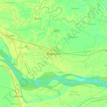
Name: Topografische Karte Begusarai, Höhe, Relief.

Ort: Begusarai, Bihar, 851117, India (25.25391 85.97488 25.57391 86.29488)

Durchschnittliche Höhe: 41 m

Minimale Höhe: 32 m

Maximale Höhe: 55 m

👉 Easily get elevation data in JSON, GeoTIFF and KML formats using Elevation API
Vielen Dank für die Unterstützung dieser Website ❤️
Spenden