
Topografische Karte Coalville
Klicken Sie auf die Karte, um die Höhe anzuzeigen.
Coalville
Coalville has a high-altitude, warm-summer humid continental climate (Köppen Dfb), characterized by extreme diurnal temperature ranges that range from extremely cold winter nights to hot afternoons in the summer. However, the high altitude and low humidity mean that mornings in the summer remain very cool, and frosts have occasionally occurred—even in July. Precipitation is moderate throughout the year, though with a minimum in summer, and snow accumulation is generally heavy due to the very cold nights between November and March, with a median of 60.1 inches (1.53 m) for the year.
Über diese Karte
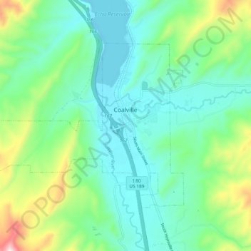
Name: Topografische Karte Coalville, Höhe, Relief.
Ort: Coalville, Summit County, Utah, United States (40.89002 -111.47093 40.93640 -111.37770)
Durchschnittliche Höhe: 1.825 m
Minimale Höhe: 1.683 m
Maximale Höhe: 2.257 m
Andere topografische Karten
Klicken Sie auf eine Karte, um ihre Topografie, ihre Höhe und ihr Relief anzuzeigen.