
Topografische Karte Harvey County
Interaktive Karte
Klicken Sie auf die Karte, um die Höhe anzuzeigen.
Über diese Karte
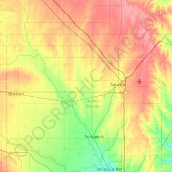
Name: Topografische Karte Harvey County, Höhe, Relief.
Ort: Harvey County, Kansas, United States of America (37.91232 -97.70182 38.17457 -97.15257)
Durchschnittliche Höhe: 442 m
Minimale Höhe: 409 m
Maximale Höhe: 479 m
Andere topografische Karten
Klicken Sie auf eine Karte, um ihre Topografie, ihre Höhe und ihr Relief anzuzeigen.
Lansing
United States of America > Kansas > Lansing
Lansing, Leavenworth County, Kansas, 66043, United States of America
Durchschnittliche Höhe: 266 m
Oakley
United States of America > Kansas > Oakley
Oakley, Logan County, Kansas, 67748, United States of America
Durchschnittliche Höhe: 930 m
Pawne River
United States of America > Kansas
Pawne River, Hodgeman County, Kansas, United States of America
Durchschnittliche Höhe: 725 m
Earlton
United States of America > Kansas > Earlton
Earlton, Neosho County, Kansas, United States of America
Durchschnittliche Höhe: 292 m
Horton
United States of America > Kansas > Horton
Horton, Brown County, Kansas, United States of America
Durchschnittliche Höhe: 327 m
Winifred
United States of America > Kansas > Winifred
Winifred, Marshall County, Kansas, United States of America
Durchschnittliche Höhe: 378 m
Norton County
United States of America > Kansas
Norton County, Kansas, United States of America
Durchschnittliche Höhe: 719 m
Sawyer
United States of America > Kansas > Sawyer
Sawyer, Pratt County, Kansas, United States of America
Durchschnittliche Höhe: 582 m