
Topografische Karte Docking
Interaktive Karte
Klicken Sie auf die Karte, um die Höhe anzuzeigen.
Docking
Docking village in the centre of the parish is situated at an elevation of 82.7 metres (272 feet), which makes it one of the highest in Norfolk. It is surrounded by arable farmland having little woodland and is a nucleated settlement, with only one historical hamlet associated with it. This is Summerfield to the north-west, the site of a separate medieval village. The two modern hamlets in the parish are Burntstalk to the west around the former workhouse, and Docking Common to the south-east which postdates the enclosure of the village common in 1859.
Über diese Karte
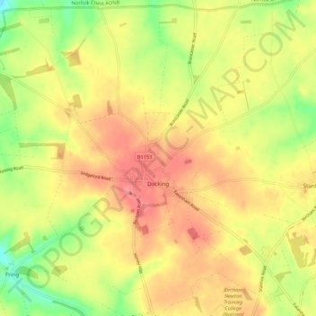
Name: Topografische Karte Docking, Höhe, Relief.
Durchschnittliche Höhe: 63 m
Minimale Höhe: 20 m
Maximale Höhe: 94 m
Andere topografische Karten
Klicken Sie auf eine Karte, um ihre Topografie, ihre Höhe und ihr Relief anzuzeigen.
King's Lynn
United Kingdom > England > Norfolk > King's Lynn and West Norfolk
Durchschnittliche Höhe: 7 m