Geolokalisieren
👉 Easily get elevation data in JSON, GeoTIFF and KML formats using Elevation API
Vielen Dank für die Unterstützung dieser Website ❤️
Spenden

Topografische Karte Mana

Klicken Sie auf die Karte, um die Höhe anzuzeigen.

👉 Easily get elevation data in JSON, GeoTIFF and KML formats using Elevation API
Vielen Dank für die Unterstützung dieser Website ❤️
Spenden

Über diese Karte

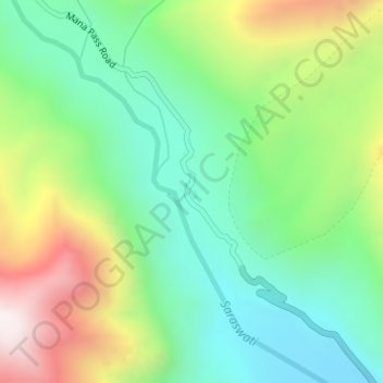
Name: Topografische Karte Mana, Höhe, Relief.

Ort: Mana, Joshimath Tehsil, Chamoli, Uttarakhand, India (30.96600 79.40952 30.96818 79.41237)

Durchschnittliche Höhe: 4.959 m

Minimale Höhe: 4.624 m

Maximale Höhe: 5.575 m

👉 Easily get elevation data in JSON, GeoTIFF and KML formats using Elevation API
Vielen Dank für die Unterstützung dieser Website ❤️
Spenden

Andere topografische Karten

Klicken Sie auf eine Karte, um ihre Topografie, ihre Höhe und ihr Relief anzuzeigen.

Dunagiri

India > Uttarakhand > Joshimath Tehsil

Durchschnittliche Höhe: 6.059 m

Malari

India > Uttarakhand > Joshimath Tehsil

Durchschnittliche Höhe: 3.458 m

Tugasi

India > Uttarakhand > Joshimath Tehsil

Durchschnittliche Höhe: 2.785 m

Joshimath

India > Uttarakhand > Joshimath Tehsil

Durchschnittliche Höhe: 2.272 m

Vielen Dank für die Unterstützung dieser Website ❤️
Spenden

Garpak

India > Uttarakhand > Joshimath Tehsil

Durchschnittliche Höhe: 3.646 m

Nanda Devi

India > Uttarakhand > Joshimath Tehsil

Durchschnittliche Höhe: 6.567 m

Tapoban

India > Uttarakhand > Joshimath Tehsil

Durchschnittliche Höhe: 2.287 m

Bamba

India > Uttarakhand > Joshimath Tehsil > Pharkia

Durchschnittliche Höhe: 3.731 m

Vielen Dank für die Unterstützung dieser Website ❤️
Spenden

Dhak

India > Uttarakhand > Joshimath Tehsil

Durchschnittliche Höhe: 2.373 m

Saraswati

India > Uttarakhand > Joshimath Tehsil > Mana

Durchschnittliche Höhe: 5.393 m

Urgam

India > Uttarakhand > Joshimath Tehsil

Durchschnittliche Höhe: 2.351 m

Badrinath

India > Uttarakhand > Joshimath Tehsil

Durchschnittliche Höhe: 4.052 m

Vielen Dank für die Unterstützung dieser Website ❤️
Spenden

Auli

India > Uttarakhand > Joshimath Tehsil

Durchschnittliche Höhe: 2.438 m

Kamet

India > Uttarakhand > Joshimath Tehsil

Durchschnittliche Höhe: 6.701 m

Trisul I

India > Uttarakhand > Joshimath Tehsil

Durchschnittliche Höhe: 6.343 m

Pangarchulla

India > Uttarakhand > Joshimath Tehsil

Durchschnittliche Höhe: 4.061 m

Vielen Dank für die Unterstützung dieser Website ❤️
Spenden

Nanda Devi

India > Uttarakhand > Joshimath Tehsil

Durchschnittliche Höhe: 6.567 m

Nanda Devi

India > Uttarakhand > Joshimath Tehsil

Durchschnittliche Höhe: 6.567 m

Chain

India > Uttarakhand > Joshimath Tehsil

Durchschnittliche Höhe: 2.031 m

Malari

India > Uttarakhand > Joshimath Tehsil

Durchschnittliche Höhe: 3.458 m

Vielen Dank für die Unterstützung dieser Website ❤️
Spenden

Badrinath

India > Uttarakhand > Joshimath Tehsil

Durchschnittliche Höhe: 4.052 m

Badrinath

India > Uttarakhand > Joshimath Tehsil

Durchschnittliche Höhe: 4.052 m