
Topografische Karte Blackball
Interaktive Karte
Klicken Sie auf die Karte, um die Höhe anzuzeigen.
Über diese Karte
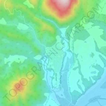
Name: Topografische Karte Blackball, Höhe, Relief.
Ort: Blackball, Grey District, West Coast, 7804, New Zealand (-42.38403 171.39195 -42.34403 171.43195)
Durchschnittliche Höhe: 147 m
Minimale Höhe: 29 m
Maximale Höhe: 525 m
Blackball is a small town on the West Coast of the South Island of New Zealand, approximately 29 km from Greymouth. Elevation is approximately 100 metres. The town was named after the Black Ball Shipping Line, which leased land in the area to mine for coal.
Andere topografische Karten
Klicken Sie auf eine Karte, um ihre Topografie, ihre Höhe und ihr Relief anzuzeigen.
Greymouth
New Zealand > West Coast > Grey District
Greymouth, Grey District, West Coast, 7801, New Zealand
Durchschnittliche Höhe: 40 m
Paddock Hill
New Zealand > West Coast > Grey District
Paddock Hill, Grey District, West Coast, New Zealand
Durchschnittliche Höhe: 781 m