
Topografische Karte Beverly Shores
Interaktive Karte
Klicken Sie auf die Karte, um die Höhe anzuzeigen.
Über diese Karte
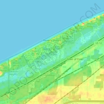
Name: Topografische Karte Beverly Shores, Höhe, Relief.
Ort: Beverly Shores, Porter County, Indiana, 46301, United States (41.66232 -87.00973 41.70954 -86.93260)
Durchschnittliche Höhe: 186 m
Minimale Höhe: 175 m
Maximale Höhe: 214 m
Andere topografische Karten
Klicken Sie auf eine Karte, um ihre Topografie, ihre Höhe und ihr Relief anzuzeigen.
Morgan Park
United States > Indiana > Porter County > Chesterton
Morgan Park, Chesterton, Porter County, Indiana, 46304, United States
Durchschnittliche Höhe: 197 m
Ogden Dunes
United States > Indiana > Porter County
Ogden Dunes, Porter County, Indiana, United States
Durchschnittliche Höhe: 184 m
Chesterton
United States > Indiana > Porter County
Chesterton, Porter County, Indiana, 46304, United States
Durchschnittliche Höhe: 200 m
Beverly Shores
United States > Indiana > Porter County > Beverly Shores > Beverly Shores
Beverly Shores, Porter County, Indiana, 46301, United States
Durchschnittliche Höhe: 182 m
Valparaiso
United States > Indiana > Porter County
Valparaiso, Porter County, Indiana, 46383, United States
Durchschnittliche Höhe: 235 m
Portage
United States > Indiana > Porter County
Portage, Porter County, Indiana, United States
Durchschnittliche Höhe: 190 m