
Topografische Karte Medicine Bow Peak
Interaktive Karte
Klicken Sie auf die Karte, um die Höhe anzuzeigen.
Über diese Karte
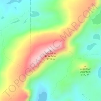
Name: Topografische Karte Medicine Bow Peak, Höhe, Relief.
Ort: Medicine Bow Peak, Albany County, Wyoming, United States (41.36020 -106.31734 41.36030 -106.31724)
Durchschnittliche Höhe: 3.396 m
Minimale Höhe: 3.233 m
Maximale Höhe: 3.655 m
Medicine Bow Peak (12,018 ft (3,663 m)) is the highest peak in the Snowy Range, a part of the Medicine Bow Mountains, about 35 miles (56 km) west of Laramie, Wyoming. It lies within Medicine Bow National Forest and is the highest point in southern Wyoming. The summit lies in extreme western Albany County, but the mountain's lower reaches stretch westward into eastern Carbon County. The summit is 12,018 feet (3,663 m) high and is visible from Snowy Range Pass, elevation 10,847 ft (3,300 m), on Wyoming Highway 130, a Wyoming Scenic Byway. The most commonly used trail to the peak is a four-mile hike featuring switch-backs and a great deal of loose rock. The trails to the peak are usually open from early June to mid October.
Andere topografische Karten
Klicken Sie auf eine Karte, um ihre Topografie, ihre Höhe und ihr Relief anzuzeigen.
Jelm Mountain
United States > Wyoming > Albany County
Jelm Mountain, Albany County, Wyoming, 82063, United States
Durchschnittliche Höhe: 2.660 m
Laramie
United States > Wyoming > Albany County
Laramie, Albany County, Wyoming, United States
Durchschnittliche Höhe: 2.219 m
Laramie
United States > Wyoming > Albany County
Laramie, Albany County, Wyoming, United States
Durchschnittliche Höhe: 2.219 m
Centennial
United States > Wyoming > Albany County
Centennial, Albany County, Wyoming, 82055, United States
Durchschnittliche Höhe: 2.577 m
Jelm
United States > Wyoming > Albany County
Jelm, Albany County, Wyoming, United States
Durchschnittliche Höhe: 2.422 m
PhinDeli Town Buford
United States > Wyoming > Albany County
PhinDeli Town Buford, Albany County, Wyoming, United States
Durchschnittliche Höhe: 2.386 m
North Twin Lakes
United States > Wyoming > Albany County
North Twin Lakes, Albany County, Wyoming, United States
Durchschnittliche Höhe: 3.258 m
Black Mountain
United States > Wyoming > Albany County
Black Mountain, Albany County, Wyoming, United States
Durchschnittliche Höhe: 2.172 m
Laramie
United States > Wyoming > Albany County > Laramie
Laramie, Albany County, Wyoming, 82070, United States
Durchschnittliche Höhe: 2.299 m