
Topografische Karte Glenwood Springs
Interaktive Karte
Klicken Sie auf die Karte, um die Höhe anzuzeigen.
Über diese Karte
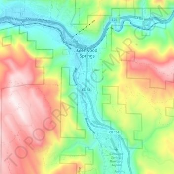
Name: Topografische Karte Glenwood Springs, Höhe, Relief.
Durchschnittliche Höhe: 2.081 m
Minimale Höhe: 1.736 m
Maximale Höhe: 2.580 m
Local food production has seen a revival in recent years. While not as consistently fecund as the extensive agricultural and viticultural areas at lower altitude such as Palisade, most types of fruit and vegetable grow well in the light and soil if well watered. Stonefruit such as cherries, peaches, and plums, pomaceous fruit such as apples and pears, and grapes are suited to the climate and terrain.
Andere topografische Karten
Klicken Sie auf eine Karte, um ihre Topografie, ihre Höhe und ihr Relief anzuzeigen.
Battlement Mesa
United States > Colorado > Garfield County
Battlement Mesa, Garfield County, Colorado, 81635, United States
Durchschnittliche Höhe: 1.806 m
Douglas Pass
United States > Colorado > Garfield County
Douglas Pass, Garfield County, Colorado, United States
Durchschnittliche Höhe: 2.435 m
Carbondale
United States > Colorado > Garfield County
Carbondale, Garfield County, Colorado, United States
Durchschnittliche Höhe: 1.919 m
New Castle
United States > Colorado > Garfield County
New Castle, Garfield County, Colorado, 81647, United States
Durchschnittliche Höhe: 1.810 m
Rifle
United States > Colorado > Garfield County
Rifle, Garfield County, Colorado, 81650, United States
Durchschnittliche Höhe: 1.731 m