
Topografische Karte Lake Karaka
Interaktive Karte
Klicken Sie auf die Karte, um die Höhe anzuzeigen.
Über diese Karte
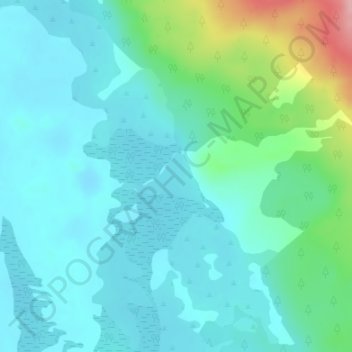
Name: Topografische Karte Lake Karaka, Höhe, Relief.
Durchschnittliche Höhe: 32 m
Minimale Höhe: 3 m
Maximale Höhe: 149 m
Andere topografische Karten
Klicken Sie auf eine Karte, um ihre Topografie, ihre Höhe und ihr Relief anzuzeigen.
Lake Rotootuauru
Lake Rotootuauru, Pouto Road, Pouto, Kaipara District, Northland, New Zealand
Durchschnittliche Höhe: 58 m
Lake Humuhumu
Lake Humuhumu, Pouto Road, Pouto, Kaipara District, Northland, New Zealand
Durchschnittliche Höhe: 68 m
Lake Waingata
Lake Waingata, Pouto Road, Pouto, Kaipara District, Northland, New Zealand
Durchschnittliche Höhe: 60 m
Lake Kanono
Lake Kanono, Pouto Road, Pouto, Kaipara District, Northland, New Zealand
Durchschnittliche Höhe: 67 m
Lake Kahuparere
Lake Kahuparere, Pouto Road, Pouto, Kaipara District, Northland, New Zealand
Durchschnittliche Höhe: 55 m
Lake Rototuna
Lake Rototuna, Pouto Road, Pouto, Kaipara District, Northland, New Zealand
Durchschnittliche Höhe: 120 m